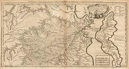
Subject: China
Period: 1741 (published)
Publication: A Description of the Empire of China and Chinese-Tartary
Color: Black & White
Twelve separate sheets, making up a large-scale map of northern China and present-day Mongolia. This is a very comprehensive 18th century map of the region compiled from a extensive Jesuit survey carried out in 1717. The missionaries used local sources and personal observation to prepare these incredibly detailed maps. Each sheet is approximately 18 x 12", with its own border and title, some with decorative cartouches. A scarce set of maps rarely offered for sale. All very good with the only faults being some surface soil and very faint offsetting.
References:
Condition: A