Subject: Eastern United States
Period: 1798 (circa)
Publication: A New Geographical, Historical, and Commercial Grammar...
Color: Hand Color
Size:
8.1 x 7.3 inches
20.6 x 18.5 cm
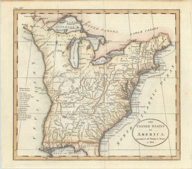
This early map depicts the young United States following the ratification of the Treaty of Paris. It details the fledgling states and the Indian lands east of the Mississippi River. The region west of the Mississippi River is completely blank with no features, but good detail is provided along its eastern side locating several named Indian villages and Revolutionary War bounty land grants including those of the Illinois Company, New Jersey Company, and Wabash Company. Several Army Lands are located in both Kentucky (unnamed) and in the Tennessee Government. Tennessee had recently split from western North Carolina and would soon gain statehood. Ohio is a small area labeled Ohio Company and Donation Lands with no sign of the other bounty grants named on Russell's larger, derivative map. The area northeast of the upper Mississippi River is largely unorganized with a few rivers, forts, and settlements. The map locates Detroit, the Lake of the Woods, and Upper and Lower Iowa in this region. In the far northeast the territory of Sagahadok is a large region in Main. In the south, the northern portion of Florida is depicted and divided into East Florida and West Florida. At the conclusion of the war, control of Florida was returned to Spain in gratitude for their neutrality during the American Revolutionary War. Georgia is listed at the fifteenth state and appears to extend to the Mississippi River. There is good detail of the river systems, towns and villages, forts, Indian lands, and more. The title misdates the Treaty of Paris to 1784, instead of 1783. Engraved by John Russell. This map was published in the 1795, 1796, 1798, and 1800 editions of Guthrie's Grammar; based on the plate number XXV at top left, this comes from one of the latter two editions.
References: McCorkle #795-11; McCorkle (18th C. Geography Books) #175-24.
Condition: A
A nice impression issued folding with a bit of faint offsetting and minor manuscript markings in the Atlantic.