Subject: Colonial Central United States & Canada, Great Lakes
Period: 1775 (dated)
Publication: Atlas Universel
Color: Hand Color
Size:
22.4 x 19 inches
56.9 x 48.3 cm
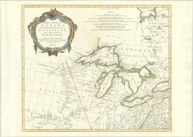
Very informative and uncommon map of the Great Lakes and upper Mississippi River region based on d'Anville's influential map of North America (1746). The map extends from the upper Mississippi River valley east to include most of Lake Ontario, north to James Bay, and southeast to Philadelphia. Chicagon (Chicago) is named along with other early settlements, numerous French forts, and Indian villages. The map includes a fine depiction of the Missouri River to Kansez including Ft. d'Orleans. D’Anville influenced not only French, but also all contemporary geographers in the second half of the 18th century. According to Tooley "His representation of the Great Lakes is superior to that of his contemporary, John Mitchell." A large rococo title cartouche decorates the sheet. This is the second state without the page number.
References: Kershaw #978; Phillips (Atlases) #647-46; Tooley (Amer) p. 317.
Condition: A
A crisp impression with contemporary outline color in the map and later color in the cartouche, on a bright sheet with the watermarks of three crescent moons and the initials "A S." There are professional repairs to a couple of small holes along the centerfold. There are extraneous creases along the sides of the sheet, well away from the image.