Subject: Eastern Africa & Madagascar
Period: 1596 (circa)
Publication: Itinerario…
Color: Hand Color
Size:
21.9 x 15.3 inches
55.6 x 38.9 cm
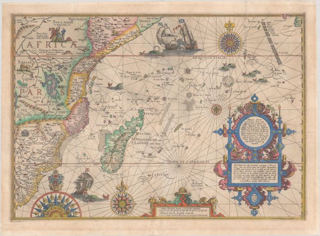
This magnificent map of the eastern coast of Africa is superbly engraved in the Flemish style by Arnold Florent van Langren. The cartouche contains a description of the region in both Latin and Dutch that credits the source as "the very best Indian maps" - referring to maps that Linschoten had access to when he was Secretary to the Portuguese Archbishop of Goa in India. The map extends from R. do Infante to Doara, and includes Madagascar and the tip of the island of Ceylon. Typical geographical features of the time are shown, such as the Lunae Montes (Mountains of the Moon), and Zaflan Lacus depicted as one of the sources of the Nile River. The extensive coastal details are likely sourced from Portuguese portolan charts, especially those of Bartolomeu Lasso. The map is richly adorned with the Christian emperor Prestor John, elephants, and lions inhabiting Africa, as well as ships, sea monsters and elaborate compass roses filling the Indian Ocean.
References: Norwich #239b; Shirley (BL Atlases) G.LIN-1Tooley (MCC-29) #168.
Condition: B+
A nice impression, issued folding on a very lightly toned sheet with the watermark of "4 W" emblazoned on a coat of arms, with a bit of printer's ink residue and minor soiling. There are archival repairs to a couple of tiny holes at fold intersections and several separations along the folds, as well as to a tear at bottom that extends 5.5" into the image along the left side of the distance scale cartouche.