Subject: China, Korea & Japan
Period: 1669 (circa)
Publication: An Embassy from the East-India Company of the United Provinces, to the Grand Tartar Cham...
Color: Hand Color
Size:
17.1 x 13.5 inches
43.4 x 34.3 cm
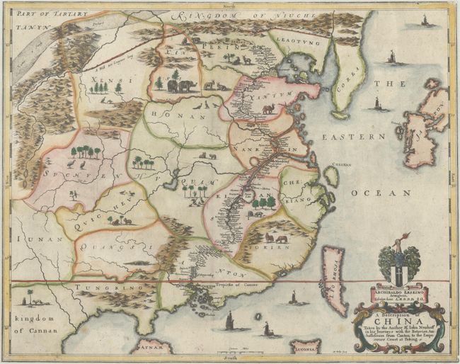
This lovely map is an English edition of Johann Nieuhoff's map of China. Nieuhoff was the official chronicler and draughtsman for the first embassy to China by the Dutch East India Company (VOC), then at the height of its power. His record of the trip became the most important source of information about China for Europe in the 17th century and one of the few non-Jesuit sources on China of this period. Nieuhoff published his description of the Chinese Empire in Dutch in 1665, accompanied by a map of China and numerous other engravings. In 1669, John Ogilby published an English translation of Nieuhoff's work, and enlisted Wenceslaus Hollar to copy the maps and engravings. This English edition is a close copy of the original Dutch map, although smaller in size and a bit more simplified. The map itself is nearly void of details, as the embassy was not allowed to venture into the interior. They traveled from Canton to Peking by way of rivers and canals, and this route is filled with place names, starkly contrasting to the rest of the map. In place of details, the map is filled with little vignettes of the indigenous animals (although it is doubtful that elephants roamed the Gobi Desert as pictured here). The map extends to include Korea, Japan and Formosa, none of which are detailed. The map is further embellished with a variety of sailing ships. Three notable changes that Hollar made to this English edition were to design a new title cartouche, add a dedication to Archibald Erskine, and to update the name of the Yellow River from Geele Rivier to Croceus or Yellow River. Engraved by Wenceslaus Hollar.
References: Caboara #68.
Condition: B
A dark impression on a bright sheet with a bunch of grapes watermark. The map has a few small spots of soiling and is trimmed to the neatlines, with a tiny chip at bottom right.