Subject: Paris, France
Period: 1600 (circa)
Publication: Geschichtsblatter
Color: Hand Color
Size:
10.9 x 8.1 inches
27.7 x 20.6 cm
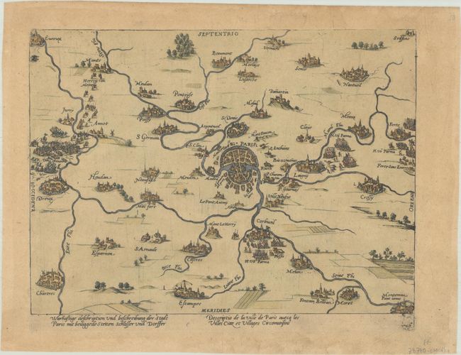
This remarkable map illustrates Paris and its environs during the siege of 1590. Part of the Wars of French Religion, the siege spanned from May 7 to August 30, 1590, when the French Royal Army, under the command of Henry IV, surrounded the city, seeking to take it from the Catholic League. Troops are graphically depicted in the west, east, and south. The map is one of the earliest maps to show Paris in the context of the surrounding Ile-de-France region. Paris is depicted in plan form with the Seine coursing through its center. Nearby cities are represented in bird's-eye view. There is a subtly persuasive element to the map, with besieged towns like Etampes and Corbeil presented with fortifications, while the towns in the Seine Valley won by Henry IV are presented without their walls, as if they were open towns. A fascinating historical map of Paris from Hogenberg's Geschichtsblatter, or history broadsheets, which was a series of several hundred prints depicting various battles during the Dutch War of Independence, published between 1569 to 1637. After Frans Hogenberg's death in 1590, his publishing firm was continued well into the 17th century by his son, Abraham.
References:
Condition: B+
On a lightly toned sheet with a hand watermark.