Subject: Antwerp, Belgium
Period: 1690 (circa)
Publication: Les Forces de l'Europe…
Color: Hand Color
Size:
10.9 x 7.8 inches
27.7 x 19.8 cm
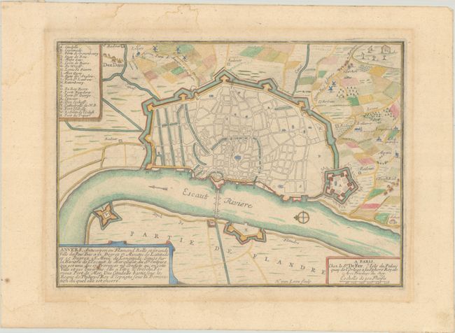
Nicolas de Fer held the title of geographer at Louis XIV's court. He was one of the most prolific publishers of plans of European cities in the late seventeenth century. The fortifications plans in Les Forces de l'Europe were designed to teach fortification techniques. Engraved by Van Loon and Schoonebeek after French engineers under the command of Vauban, the renowned military architect. The illustrations often include a description and a legend with the principal buildings; each city plan includes both fortifications and street layout.
A handsome bird's-eye fortification plan of Antwerp and the surrounding countryside. The map is oriented with north to the left by a small compass rose in the river Scheldt. The plan shows the internal layout of the city, churches, military barracks, citadel and city walls and canals. The surrounding countryside is graphically depicted with fields, windmills and even a gallows at upper right. A key at left locates 22 important locations.
References: Pastoureau, FER IX [10]; Pollak #21, p. 40.
Condition: B+
A nice impression on paper with a bunch of grapes watermark and a single wormhole near the center. There is light toning around the outside of the border and some faint dampstains mostly in the top and bottom blank margins.