Subject: Europe
Period: 1589 (circa)
Publication: Itinerarium Sacrae Scripturae
Color: Hand Color
Size:
14.1 x 9.4 inches
35.8 x 23.9 cm
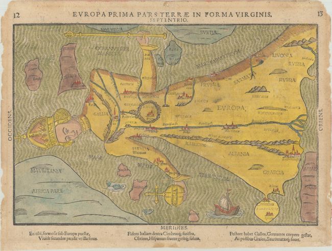
Heinrich Bunting’s Itinerarium Sacrae Scripturae included some of the most fanciful and curious cartographic representations, including the world in the shape of a cloverleaf and Asia as Pegasus. For his map of Europe, he chose a design originated by Joannes Bucius in 1537, which presents Europe in the form of a queen. Spain forms the crown and head, France and Germany the neck and bust, Bohemia the heart, Italy the left arm holding an orb (Sicily) and Denmark the right arm holding a scepter with Britain as the flag. The remainder of the figure is a flowing robe with Greece and Russia at the feet. Major rivers, cities and mountain ranges are included. This map first appeared in the 1587 edition of the Itinerarium, and several different woodblocks and copperplates were used in various editions through 1663. This example is from the first block. German text on verso with an explanation of the image.
References: Rumsey #15301; Tooley (MCC-1) #2; Van der Heijden (Kaarten van Europa) #42.
Condition: B+
A nice impression on a lightly toned sheet with very light soiling and about a dozen small worm holes that have been archivally repaired, with insignificant loss of image. The centerfold has been archivally reinforced on verso and there are some small chips along the edges of the sheet and remnants of hinge tape on verso.