Subject: World, World War II
Period: 1943 (dated)
Publication:
Color: Printed Color
Size:
35.5 x 14.9 inches
90.2 x 37.8 cm
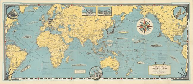
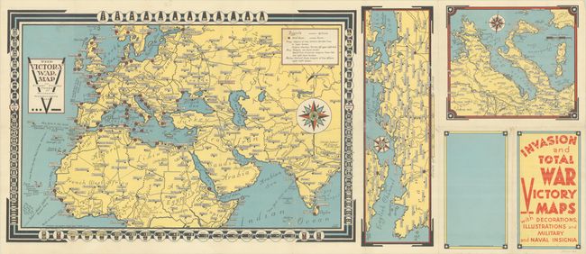
This elaborate wartime map is centered on the Pacific theater of war. It locates numerous Allied naval bases, railroads, British & French colonial possessions, and the Axis power countries in menacing black. The oceans are filled with illustrations of Allied military power including ships, submarines, and aircraft with distances between various ports noted. Illustrations along the border feature "A Yank Tank", "Flying Fortress", and a "New Anti Aircraft Gun Machine." Chase describes his production as "A Battle Map, to set the stage for 'total war' on land and sea; And, in the border, just a hint - A prayer - for total Victory!" The verso contains three smaller maps: Europe, English Channel, and the region around Italy. Self-folding (4.5 x 8.0"). Dated 1942 on the map and 1943 on the rear panel of the brochure.
Ernest Dudley Chase (1878-1966) was one of the leading figures in pictorial mapmaking during the middle of the 20th century.
References: Curtis & Pedersen (War Map) pp. 154-57; Hornsby (Picturing America) pp. 31-34; Rumsey #8531.
Condition: A
A colorful example on a clean sheet with a few tiny splits at the fold junctions. Issued folding.