Subject: World
Period: 1548 (circa)
Publication: Geografia di Claudio Ptolemo Alexandrino
Color: Black & White
Size:
6.8 x 5.1 inches
17.3 x 13 cm
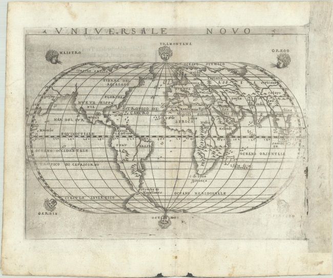
This small copperplate map was one of two modern world maps that Gastaldi included in his edition of Ptolemy's Geogrpahia. Interestingly, neither of Gastaldi's world maps were Ptolemaic, although this oval-shaped map still includes fascinating cartographic misconceptions. North America is shown connected to Asia, and there are only four place names in North America: Tierra de Bacalaos, Florida, Nueva Hispania and Mexico (City). In South America, the Nile River is depicted flowing north-south, with the Strait of Magellan separating the continent from a relatively small Southern Continent. The map is based on Gastaldi's larger 1546 map of the world, which was also oval-shaped, however this smaller edition includes 6 windheads. Italian text on verso.
Gastaldi's edition of Ptolemy was the earliest pocket atlas and marked the shift from woodcut maps to maps engraved on copper. The transition from wood block to copper plate allowed for finer detail, which was important for Ptolemy's Geografia as it contained the first regional maps of the American continent and was the most comprehensive atlas published between Waldeemuller's Geographiae of 1513 and Abraham Ortelius' Theatrum of 1570.
References: Mickwitz & Miekkavaara #214-59; Shirley #87.
Condition: B+
A mostly dark impression that is faint at far right, with some printer's ink residue and marginal soiling. There are two worm tracks along the centerfold in the image that have been professionally infilled, with a few very short portions of latitude and longitude lines replaced in facsimile. The paper has been professionally de-acidified and buffered to preserve and prolong its life in accordance with the recommended practices of the Institute of Conservation. There appears to be a blank plate that abuts the map plate at far right, and may be a sign of a repair that was made to the map plate.