Subject: Yellowstone, Wyoming
Period: 1948 (dated)
Publication:
Color: Printed Color
Size:
15.6 x 15.7 inches
39.6 x 39.9 cm
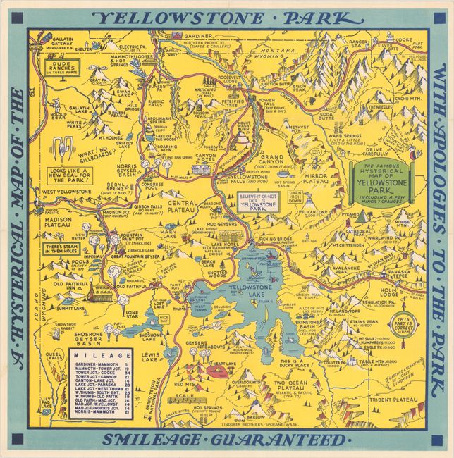
This graphic map of Yellowstone National Park was "hatched & scratched" by Jolly Lindgren. It depicts the park in a light-hearted manner, with a number of silly visual puns, including hot springs drawn as coils radiating sizzle lines, a hot pan representing Frying Pan Spring, a pool table standing in for Congress Pool, and a holdup bear appearing as a bear with a pistol. Old Faithful sings, "I'm Forever Blowing Bubbles," while Folsom Peak has a jail cell on top. Lindgren also inserts jokey asides, such as a parenthetical "Are Ya Hurt?" beneath Gibbon Falls and "Hell for Certain" under Brimstone Basin. An alternate title surrounds the map: A Hysterical Map of the Yellowstone Park with Apologies to the Park Smileage Guaranteed. This is the later edition with a few changes from the 1936 original, most notably the addition of a mileage table at bottom left and a slightly smaller size.
The Lindgren brothers of Spokane, Washington, specialized in humorous maps of state parks. The brothers founded their business in 1928 with Hjalmer (Jolly) serving as the artist and Oscar (O.S.) overseeing administration and production. They produced their first map in 1932 - Hysterical Map of the Spokane Country Slightly Cockeyed - which was designed to be "hysterical" rather than "historical." Their comical map was successful, and in 1933 others followed, including Puget Sound, Rainier National Park, and Yellowstone National Park. Despite the Great Depression, tourism in National Parks increased significantly in the 1930s, and visitors were eager for souvenirs of their trips. The Lindgren brothers capitalized on this trend, producing numerous National Park maps. Beginning with the Yellowstone map, Jolly developed a standardized format with a bold blue border incorporating the title, yellow denoting land (because of Yellowstone), red for roadways, black for text, and accents of green and blue. This style and color scheme became Jolly's signature style and was continued on all of his Hysterical maps of National Parks. The Lindgren brothers had hired Ted Turner as director of sales in 1930, and his role in the business gradually evolved until he became an official partner in 1949, and the business was renamed Lindgren-Turner. After World War II, the map business declined, so the Lindgrens and Turner innovated to create souvenir decals, which became hugely popular. After Jolly Lindgren's death in 1952, Oscar Lindgren and Ted Turner further extended the product line to include postcards (called "King Size Mapcard").
References: cf. Hornsby (Picturing America) plt. 6; Clinton (IMCOS #125) pp. 27-39.
Condition: A
A bright, colorful example issued folding. There is a tiny separation at the central fold intersection and a hint of wear along the folds.