Subject: Long Island, New York
Period: 1857 (dated)
Publication:
Color: Black & White
Size:
34.6 x 24.8 inches
87.9 x 63 cm
The Office of Coast Survey is the oldest U.S. scientific organization, dating from 1807 when Congress directed that a "survey of the coast" be carried out. By 1836, it was called the U.S. Coast Survey and in 1878, the name was changed to the U.S. Coast and Geodetic Survey. Today the Office of Coast Survey is a division of the National Oceanic and Atmospheric Administration NOAA.
The survey teams, composed of civilians as well as Army and Naval officers, charted the nation's waterways and produced a wide array of reports, survey charts, hydrographic studies of tides and currents, astronomical studies and observations, and coastal pilots. These charts are an important record of the changing nature of the nation's coastlines. In additional to coastal charts, the U.S. Coast and Geodetic Survey produced land sketches, Civil War battle maps, and the early aeronautical charts.
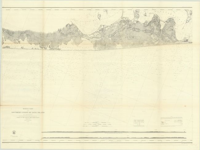
This extraordinary chart is part of a three-sheet set of Long Island and depicts the southeastern coast from Moriches Bay to Napeague Harbor, including Sag Harbor, East Hampton, Southampton, Quogue, Bridgehampton and Amagansett. It extends as far north as Gardiner’s Island and Hog Neck. The interior is depicted in considerable detail along with a wealth of practical information for the mariner in the sea. Two prospect views along the bottom illustrate the coast south of Speonk and the coast south of Shinnecock.
References:
Condition: B+
Issued folding on a bright sheet with a few faint spots. Trimmed close to the border at top left.