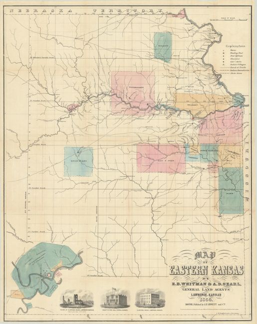
Subject: Eastern Kansas
Period: 1856 (dated)
Publication:
Color: Hand Color
Size:
21.1 x 26.8 inches
53.6 x 68.1 cm
This map was compiled by Lawrence, Kansas-based E.B. Whitman and A.D. Searl, abolitionists who were promoting northern or "free state" emigration to Kansas. With the recent passage of the Kansas-Nebraska Act (1854), the territory was embroiled with the slavery issue and numerous confrontations played out from 1854-59, resulting in over 50 politically-motivated killings and the nickname "Bleeding Kansas." The tensions resulted in a separate constitution and capital for each side, with Lecompton noted on the map as the territorial capital (pro-slavery) and Topeka as the free-state capital noted as the "temporary state capital." In the region between Lecompton and Lawrence, three separate encampments for Shannon's Posse (pro-slavery militants) are noted as of December 10, 1855.
Political divisions to the side, Kansas' new territorial status sent off a wave of settlement with large quantities of land available for sale, including newly surveyed lands extending from the Nebraska line south to Fort Scott (the northern two-thirds of present-day Kansas). Much of this land, however, was previously assigned to various native groups including the Delaware, Shawnees, Miamis, Sacs & Foxes, with the familiar grid pattern of the Public Survey System freshly laid on top. Whitman & Searl color-coded these lands possibly to warn free-state settlers away from these areas due to the potential for conflicts with natives. The map also shows excellent detail of the roads, trails, forts, Indian villages, trading posts, and more. Illustrations at bottom include an inset map of Fort Riley ("the geographical center of U.S. possessions"), Eldridge House before/after it was burned down by pro-slavery vigilantes, and Constitution Hall. Lithographed by L.H. Bradford and issued by John Punchard Jewett, who is best known as the publisher of Uncle Tom’s Cabin. No covers present. A fascinating early map of Kansas in the midst of both conflict and growth.
References: Streeter Sale #3903.
Condition: B+
Issued folding and now flattened and professionally backed along the folds to repair and reinforce tiny splits at the fold junctions. There is some minor creasing and light toning mostly at right.