Subject: World
Period: 1770 (circa)
Publication: A New Geographical, Historical, and Commercial Grammar...
Color: Black & White
Size:
14.6 x 7.5 inches
37.1 x 19.1 cm
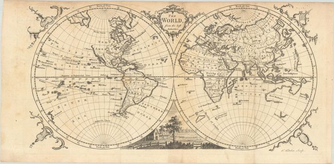
This interesting and elegantly engraved double-hemisphere world map predates Cook's voyages and the Russian discoveries in Alaska. The northwest coast of North America is left undefined north of Cape Mendocino. The British Empire is noted to the east of the Mississippi, with Louisiana to the west. Australia's borders are incomplete, with Van Dimens Land appearing as a partially delineated coast. New Zealand is also just a portion of coastline. Jeso and an unnamed conjectural coastline appear north of Japan. Fragments of discovered land are noted on both hemispheres, including a section of Terra Australis, Land seen by Quiras and Mendana, and Cape Circoncision. The map is decorated with an ornate title cartouche, a pastoral vignette, and rococo flourishes.
References: McCorkle (18th C. Geography Books) #155-1.
Condition: B
A nice impression with light toning and foxing, and some minor offsetting. Issued folding.