Subject: Southwestern United States
Period: 1848 (published)
Publication:
Color: Black & White
Size:
68.3 x 30 inches
173.5 x 76.2 cm
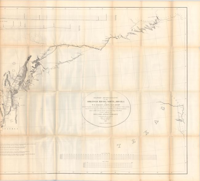
An important Mexican-American War period map that shows the route of Col. Kearny and his Army of the West as they traveled from Ft. Leavenworth to Los Angeles via Santa Fe and San Diego. It provides detailed information of what would become the Southern Trail to the California gold fields. Wheat calls the map “a document of towering significance” and an important milestone in the cartographic development and accurate determination of the geography of the Southwest. A large map printed on three sheets, joined as issued.
The map is accompanied by a complete example of Emory's important report documenting the 1846-47 journey through an untamed countryside where “barrenness and desolation hold their reign.” Emory's report is a major contribution to the geographical knowledge of the American West and an enjoyable read, with passages such as "I stopped in the little town of Isoletta, to visit my friend, the accolade, who has the reputation, Indian though he be, of being the most honest man and best maker of brandy in the territory." The report summarizes the activity of the U.S. Army of the West after the capture of New Mexico with important early views of the region. It is further illustrated with 26 lithographed views including San Diego, 3 battle maps, and 14 botanical plates. Published by Wendell and Van Benthuysen in Washington. 416 pages. Hardbound in contemporary brown cloth with paper title label on spine and a built-in slipcase for the map in the back cover.
References: Wheat (TMW) #544; Wagner & Camp #148:3; Howes #E-145.
Condition:
The map is issued folding and has short separations at fold intersections, light toning mostly along the folds, tinly spots of foxing on the left-hand sheet, and several small stains at far left. The plates are mostly bright with light to moderate foxing. The text is moderately foxed with occasional toning and damp stains. The covers are stained and cockled in the bottom corners. The spine has small chips at top and bottom and the paper title label is largely missing. Large map (B+) / Plates and Binding (B)