Subject: Western United States
Period: 1883 (published)
Publication: Hayden's 12th Annual Report
Color: Printed Color
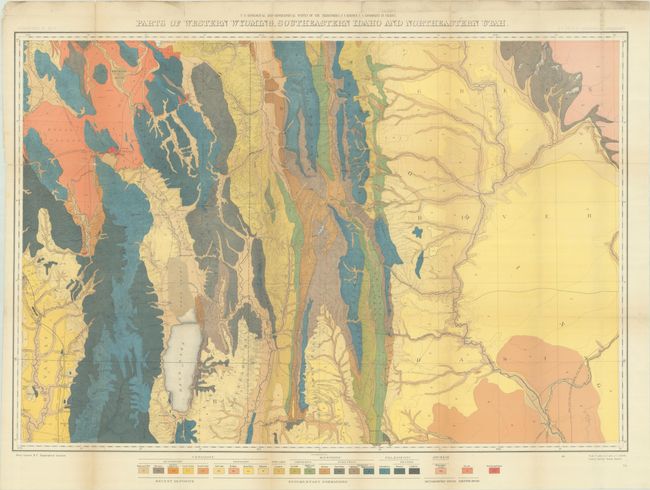
Both of these vibrant maps were issued in Hayden's 12th Annual Report for 1879 but not published until 1883:
A. Geological Map of Portions of Wyoming, Idaho and Utah, (36.3 x 20.5"). This handsome and colorful map mostly covers part of Idaho eastward to the Sweetwater Range. Topography and hydrology are nicely developed and an abundance of towns and villages are shown. Bear Lake is at lower left bordering Idaho and Utah, Rawlings is at lower right with a portion of the Union Pacific Railroad detailed. The map locates wagon roads, trails, and sand dunes, and has fine watershed details. Mining activity is clearly shown in place names like Miner's Delight, Camp Stambaugh, Atlantic City, etc. It locates Blackfoot, Rose Fork Agency (Fort Hall), John Gray's Lake, Caribou, the Wind River or Shoshone Reservation, and much more. Taylor's Bridge on the Snake River pre-dates Idaho Falls. Condition: A colorful example with several fold separations, some of which have been partially closed on verso with archival tape, and some minor loss at a couple fold intersections. There is light toning along the fold lines and a binder's trim at left. (B)
B. Parts of Western Wyoming, Southeastern Idaho and Northeastern Utah, (33.3 x 24.5"). Very detailed sheet that shows all land from the Green River Basin in the east to the Bear River Range to the west. It maps the Aspen Range, Salt River Range, and the Wyoming Range in the north, and extends south below Bear Lake to Logan. Locates numerous settlements and includes Fremont's Lake. Condition: A colorful example with several short fold separations and minor loss at one fold junction. There is minor soiling in the top blank margin. (B+)
References: Wheat (TMW) #1296.
Condition:
See description above. Issued folding.