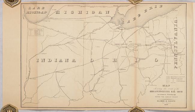
Subject: Pennsylvania & Ohio
Period: 1849 (published)
Publication:
Color: Black & White
Size:
15.1 x 9.5 inches
38.4 x 24.1 cm
This is the first report for the Ohio & Pennsylvania Railroad, made by its chief engineer Solomon Roberts. The company's charter was to extend the Pennsylvania Railroad beyond Pittsburgh in order to connect with other major railroads and canals in Ohio and points west. The frontispiece to the 24-page report is a folding map showing the proposed 101-mile track from Pittsburg to Massillon. The map extends as far as Chicago, and delineates the lines of the Chicago Railroad, St. Louis Railroad, Columbus & Cleveland Railroad, Ohio Canal, and others. The Ohio & Pennsylvania Railroad operated until 1856 when it was consolidated with the Ohio & Indiana Railroad and the Fort Wayne & Chicago Railroad, together forming the Pittsburgh, Fort Wayne & Chicago Railway. Paper wrappers.
References:
Condition: B+
Folding map is lightly toned with a hint of offsetting. Text has some minor staining in the last 12 pages. Wrappers are soiled and lightly worn.