Subject: World
Period: 1691 (circa)
Publication:
Color: Hand Color
Size:
22.4 x 18.8 inches
56.9 x 47.8 cm
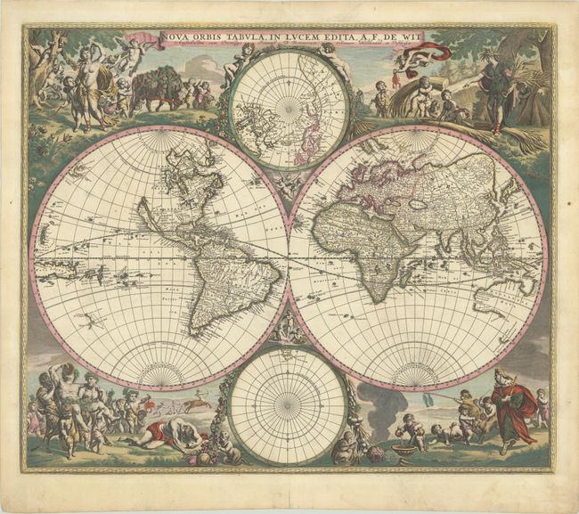
This is one of the most attractive double-hemispherical world maps of the late seventeenth century. The corners are filled with images of the seasons, the zodiac, and the elements, all combined within four well-composed vignettes. At top left is a personification of Spring, who also represents Virgo, with the element of Air billowing her robes. The bull of Taurus and the ram of Aries are shown to the right. The top right vignette represents Summer, with the shore in the background illustrating the element Water. A putti holds a crab representing Cancer, and another holds the lion of Leo. The twins of Gemini flank the inset of the North Pole at top. The lower left scene presents Autumn and Earth with a wine-imbibing Bacchus and a scene of drunkenness. The signs for Scorpio and Libra are held by two followers, while Sagittarius gallops in the background. Winter holds court in the final vignette, with the element of Fire shown to the left. Aquarius is represented by a child pouring water into a basin. A group of raucous children in the background hold a goat representing Capricorn and a fishing pole with the double fish of Pisces.
De Wit first published this world map circa 1662, however a number of changes were made to the plate in subsequent years. In state 2, the number "2" was engraved at top right, and in state 3, an outer border was added to the map and cherubs were added to the cusps. Circa 1690, a fourth state appeared with numerous changes within the western hemisphere. A key update was the depiction of the five Great Lakes with Lakes Superior and Michigan open-ended in the west, rather than one large semi-circle with an open western end. The island of California was updated from the Briggs model with a flat northern coast to an indented northern coast, and the northwestern coast of North America was left blank, eliminating Anian from earlier states. A number of changes were made in Canada, which are also visible within the North Polar inset, and place names were added in North America, including Montreal, Powhatan and N. Amsterdam (New York City). In addition, Nova Guinea and Quiri Regio were added in the South Pacific. Other items of interest, which remain the same as in the earlier states, are the mythical L. Parime astride the equator in South America, with the imaginary golden city of Manoa on its shores. The inset of the South Pole is nearly blank save for the very tip of South America and Tierra del Fuego. Asia still displays a Japan with an oversized Iedso (Hokkaido) shown on the map of the Western Hemisphere. No changes were made to Australia, Tasmania or New Zealand, which all have only partial coastlines. This is the fifth state, with the addition of reference letters in the borders of the hemispheres, published between 1691-96.
References: Carhart #3.5; Shirley #499.
Condition: A
A sharp impression with full contemporary color on a bright sheet that has been backed with Japanese tissue to strengthen the paper and repair a few small cracks. The paper has been professionally de-acidified and buffered to preserve and prolong its life in accordance with the recommended practices of the Institute of Conservation.