Subject: Colonial Eastern United States & Canada
Period: 1755 (published)
Publication: General Magazine of Arts & Sciences
Color: Black & White
Size:
19 x 7.5 inches
48.3 x 19.1 cm
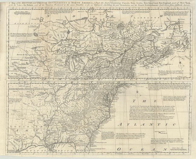
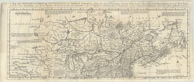
These scarce maps were issued to accompany a 4-part account of North America. Both are filled with interesting historical and descriptive notes, as well as the locations of Indian tribes, villages, forts, and early settlements. The first map covers Canada, New England, parts of New York and Pennsylvania, and the Great Lakes. Issued just prior to the French and Indian War, it presents a decidedly British point of view with several interesting boundaries shown, including the Bounds of the Six Nations, the Bounds of Hudson Bay by the Treaty of Utrecht, and Northern Bounds of New England by Charter Nov. 3rd 1620, and which extends Westward to the Sth. Sea.
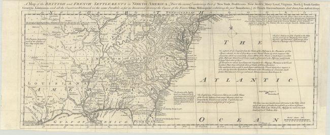
The second map is the southern sheet, which covers the region from Long Island through northern Florida, and extends well west of the Mississippi. The map's unabashedly British perspective is reflected in a note at top left stating: "The Bounds of Virginia and New England by Charters May 28, 1609 and Nov. 3, 1620 extending from the Atlantic Ocean to the South Sea out of which our other Colonies were granted." Lord Granville's Limits are also shown extending past the western edge of the map and the Bounds of Carolina stretch well into Florida. This is the first time we have offered this fascinating pair of maps together.
References: Jolly #GENMAS-68 & 69; Kershaw #352; McCorkle #755.6; Sellers and Van Ee #81.
Condition:
Both maps are crisp impressions issued folding, now flat, with light toning and soiling, and minor extraneous creasing along the folds. The northern map is in B condition with a narrow 0.5" strip along the left fold that has been professionally replaced in facsimile. Two short sections of neatline at bottom and right have also been replaced in facsimile. The southern map is in B+ condition with a professional repair to a chip in the bottom right margin and just the corner of neatline replaced in facsimile. The first image is a composite image - the map is on two separate sheets.