Subject: Atlases
Period: 1710 (circa)
Publication:
Color: Hand Color
Size:
13.4 x 21.2 inches
34 x 53.8 cm
This composite atlas consists of maps attributed to publisher Jeremias Wolff (10 maps) as well as Mathias Seutter (6 maps), who served as an engraver to Wolff before establishing his own publishing firm in 1707. According to Tooley's Dictionary of Mapmakers, Wolff held various professional roles including clockmaker, printseller and publisher in Augsburg. While Wolff is primarily associated with the print market, he also dabbled in map publishing en route to becoming one of the largest publisher's in Augsburg. According to WorldCat, Wolff was active from approximately 1690 until his death in 1724. Interestingly, Wolff was also the grandfather of Johann Friedrich Probst, who acquired much of Seutter's stock and eventually inherited Wolff's map plates as well.
Of particular interest in this composite atlas are the world map and 5 continent maps which are all directly based on works by Guillaume Delisle. The double-hemisphere world map is centered on the French royal coat of arms and allegorical female representations of the four continents. The map is up-to-date for the period with the most recent exploration routes noted, including those of Tasman and Dampier. In keeping with Delisle's desire for accuracy, the Pacific Northwest coast of North America is left blank above C. Mendocin, there is no evidence of Antarctica, and only a partial coastline of New Zealand is depicted. Delisle used accounts from French explorers and colonizers of the Gulf of Mexico region. He also had access to accounts from survivors of La Salle’s expedition in the late 1680's. Despite his efforts to produce highly accurate maps, this map shows New Guinea connected to Australia, and it appears that Japan is connected to the mainland (Terre de Yeco) to the north. In addition, Terre de la Compagnie appears to the northeast of Japan with a partial outline continuing in the western hemisphere accompanied by a note regarding its discovery by Dom Jean de Gama. The tracks of major explorers and their discoveries are charted in the oceans. Another cartouche in the cusp contains Wolff's imprint.
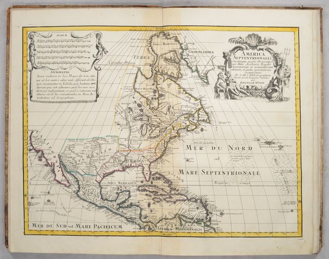
Also of interest is Delisle's historically important map of North America, which made three significant contributions to the cartography of North America. It was the first map to revert back to the peninsular form for California, even before the publication of Kino's report. Although on close inspection one can see a small gap at the head of the Gulf of California, leaving open the possibility that California might still be an island. Delisle's second contribution to North American cartography was a more accurate rendition of the Great Lakes region. Third, Delisle corrected the position of the lower Mississippi River, moving the mouth of the river from an area near Galveston Bay to a more correct location in Louisiana. The English settlements are confined east of the Allegheny Mountains, French forts and settlements are located throughout Louisiana and Spanish forts are clustered around Santa Fe. The first mention of what would be called the Sargasso Sea is noted in the North Atlantic. The map is decorated with an aquatic-themed figural cartouche and a draped scale of miles.
The other continent maps include South America, Asia, Africa and Europe. The regional European maps include Spain, France, Italy, Germany, Russia, and portions of Central and Eastern Europe. The full list of maps includes:
Mappa Totius Mondi...per G. de L'isle... Condition: Contemporary outline color with some light staining and dampstains along the left and right borders. (B)
Europa Delineata Juxta Observatio...Per G. de L'isle...Jeremiae Wolfii Aug: Vindel: Condition: Staining, soiling, and an archivally repaired edge tear at bottom that extends 3" into the image. There is a pair of wormtracks along the upper centerfold. (C+)
Asia Concinnata Secundum Observa...Per G. de L'isle...Jeremiae Wolfii. Condition: Light staining mostly around the centerfold and title cartouche at upper left. (B)
Hispania ex Archetypo...Per G. de L'isle...Jeremiae Wolfii Aug Vind. Condition: Light staining mostly along the centerfold and in the blank margins. (B)
Africa Concinnata Secundum Observationes...Per G. de L'isle...Jeremiam Wolff. Condition: Light staining along the centerfold. (B+)
America Meridionalis Concinnata Secundum Observationes...Per G. de L'isle...Jeremiam Wolff. Condition: Staining along the centerfold. (B)
America Septentrionalis Concinnata Secundum Observationes...Per G. de L'isle...Jeremiam Wolff. Condition: Light staining along the centerfold. (B+)
Theatrum Belli sive Novissima Tabula Qua Maxima Pars Danubii et Praeserim Hungaria...Matthaeo Seutter, Chalcographo Augustano. Condition: There is a small dark stain along the left border and light staining along the centerfold. (B)
Mappae Imperii Moscovitici...Matth: Seutter... Condition: Full contemporary color with some light staining throughout. The left and right sheet edges have been reinforced with old paper on verso. (B)
Tabula Hungaria...Ier. Wolfii Aug. Vind: Condition: Light staining along the centerfold. (B+)
Germania Secundum Observationes...Per G. de L'isle...Jeremiae Wolfii. Condition: Staining along the centerfold and upper right. (B)
Imperii Moscovitici pars Australis in Lucem Edita per Guillielmum de l'Isle...per Matthaeum Seutter... Condition: Full contemporary color with light staining. (B+)
Nova Mappa Maris Nigri et Freti Constantino Politani...Matth: Seutter. Condition: Full contemporary color with dampstains extending into the image at left, right and top. (B)
Nova Mappa Geographica Maris Assoviensis...Matthaeum Seutter Chalcograph. Condition: Full contemporary color with dampstaining and archival repairs to a couple of tears at left. (B)
Gallia Concinnata ad Magnum Numerum Mapparum...Matth: Seutter Calc. Condition: Full contemporary color with a few wax spots along the middle centerfold. (B+)
Italia Secondum Observationes...Ierem Wolfii. Condition: Staining along the upper centerfold. (B)
Hardbound in quarter leather with tips over marbled boards.
References:
Condition: B
See description below for map condition and grades. Maps have contemporary outline color unless specified below. Binding has moderate wear with a couple of gouges on the covers and a few small chips to the spine.