Subject: Western Hemisphere - America, Atlantic Ocean
Period: 1513 (published)
Publication: Geographiae
Color: Black & White
Size:
17.6 x 14.6 inches
44.7 x 37.1 cm
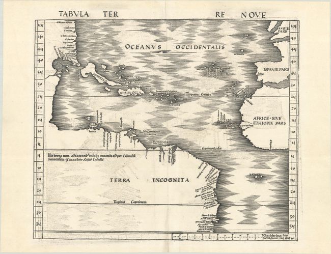
This is Waldseemuller's landmark map covering the Atlantic coastline of the Americas, and is one of the earliest maps available to collectors of American maps. Waldseemuller's map was the first map devoted to the Americas to appear in an atlas. His map is often referred to as the Admiral's Map because Waldseemuller attributed his source of information on the New World to 'the Admiral' - referring to Columbus. This was a change, however from his 12-sheet world map of 1507, on which Waldseemuller named the new continent America after Amerigo Vespucci. He soon realized his error and corrected it on his map of the Americas, first published in 1513, in which the new world was named simply Terra Incognita. Waldseemuller attempted further to distance himself from the false credit he had given to Vespucci by specifically crediting Columbus with two lines of Latin text, which read, "Hec terra cum adiacentib insulis inuenta est per Columbu ianuensem ex mandato Regis Castelle" (this land with its adjacent islands was discovered by Columbus, sent by authority of the King of Castile). Waldseemuller also used Portuguese manuscript maps as sources, including the portolan charts by Cantino (1502) and Caveri (circa 1505), particularly for the coastal place names shown in North America.
The geography delineates the Atlantic from latitudes 35° south to 55° north, with a surprisingly accurate depiction of the American coastline that presents a continuous coastline from North to South America. An early outline of the Florida peninsula appears, well before discoveries of Ponce de Leon's exploration of the region could have reached Europe. In addition, the rudimentary shape of the Gulf of Mexico is included, alluding to a possible unrecorded voyage prior to Alonzo Alverez de Pineda's 1519 expedition. Cuba is also shown, and is labeled Isabella in honor of Queen Isabella of Spain.
This map was published in one of the most important atlases ever published. Waldseemuller's Geographiae was the first atlas to include a separate map of the newly discovered parts of the world. It appeared in only two editions, this example being from the first edition. Blank verso.
References: Burden #3; Mickwitz & Miekkavaara #205-29; Schwartz & Ehrenberg, pp. 31 & 34;
Condition: B+
A dark impression on a bright sheet with no watermark. There is light offsetting, a few minute worm holes, and a small remnant of hinge tape on verso.