Subject: World
Period: 1596 (published)
Publication: Itinerario, Voyage ofte Schipvaert van J.H. van Linschoten...
Color: Hand Color
Size:
22.6 x 15.6 inches
57.4 x 39.6 cm
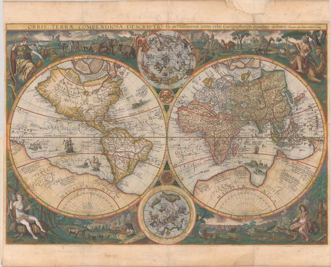
This stunning, double-hemisphere world map was published by Jan Baptist Vrients for the first edition of Jan Juygen van Linschoten's Itinerario, one of the most important early accounts of India, the East Indies, and the Portuguese colonies in Africa and South America. The map is largely a copy of Petrus Plancius' map of 1594, however Vrients made numerous updates to the decorative elements. Cartographically, Vrients' map is nearly identical to Plancius' edition, depicting a massive Southern Continent (Terra Australis) and showing new information, based on Portuguese reports, on the far-west coast of America and the western coastline of Africa. Korea is shown as a peninsula, and the shape of Japan is improved. In addition, Virginia is noted on the east coast, a relatively early appearance. However, Vrients also made a few key cartographic updates. The Banda Islands, important Indonesian islands in the spice trade, are named, and Novaya Zemlya and the northern coast of Asia are drawn more accurately.
Vrients also copied Plancius' celestial hemispheres, but the allegorical representations of the continents are re-imagined. Similar to Plancius, Vrients utilizes female figures and animals to represent the continents, however Plancius depicted 6 continents, while Vrients condenses the images into 4 continents: Europe, Asia, Africa and America. Europe sits on a globe and holds a scepter; Asia sits on a camel and holds incense and a sword; Africa sits on a crocodile and holds a bow; and America sits on an armadillo and holds a spear, with cannibals in the background. The map was engraved by the brothers Arnold and Hendrick van Langren, whose imprint is at bottom center.
This map by Vrients is quite rare as it was published in the first edition of Itinerario of 1596, while later editions featured the 1594 map by Plancius (on which this map was based), although an occasional copy of Vrients' map can be found in the 1599 edition.
References: Shirley #192.
Condition: B
A sharp impression with full contemporary color with gilt highlights, issued folding on a sheet with a horn coat of arms watermark. There is light soiling, offsetting of the color, light wear along the folds, and tiny holes at fold intersections. A chip confined to the top margin has been replaced with old paper, and an adjacent fold separation that enters 1" into the image has been archivally repaired. Narrow side margins, as issued.