Subject: Arabia, Egypt
Period: 1774 (published)
Publication:
Color: Hand Color
Size:
8.3 x 10.6 inches
21.1 x 26.9 cm
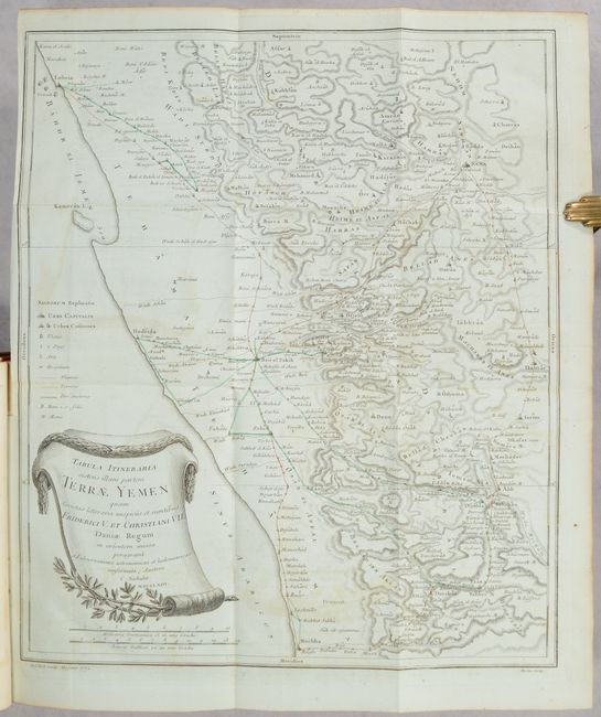
This is the complete first volume of Carsten Niebuhr's ground-breaking Reisebeschreibung nach Arabien. The German cartographer and explorer Carsten Niebuhr was the sole survivor of the six-man Danish Arabia expedition (1761-67). Upon his return, he wrote four books on his discoveries: Beschreibung von Arabien (1772) and the three volumes of Reisebeschreibung nach Arabien (Vol. I - 1774; Vol. II - 1778; and Vol. III - posthumously published in 1837). According to Ankary, "Niebuhr's expedition clearly represents a radical turning point in the way of studying the Arabian Peninsula and drawing maps of it." Indeed, his work deepened the European understanding of the region, and his maps set the groundwork for further scientific mapping. This volume covers the first couple years of the expedition, with stops in Constantinople, Alexandria, Cairo, Sinai, Jeddah, and around Yemen. The volume features 15 maps and plans on sturdy bluish sheets, including one large folding map, Tabula Itineraria Sistens Illam Partem Terrae Yemen... (15.6 x 18.4"). It covers the coast of Yemen from Loheaia (Al Luhayyah) south to Mocha, and spans inland to Damar (Dhamar). It also identifies several other towns and cities, including Sanaa and Hodeida (Al Hudaydah), locates the island of Kamaran, and features remarkable topographical detail. In addition to the maps and plans, there are 58 engravings showing views, local culture and dress, hieroglyphics, and more. German text. Published in Copenhagen by Nicolaus Moller. 506 pages. Rebacked in leather over contemporary leather boards.
References: Ankary, pp. 108-110.
Condition: B+
The Yemen map is very good with light offsetting, marginal toning, and creasing in the top left margin. The other maps and engravings are in very good to near fine condition, with minor to light foxing and toning. Text has light foxing. Covers are scuffed and worn with bumped corners. Rebacked. Ex-libris.