Subject: Arabia, India & Eastern Africa
Period: 1706 (published)
Publication: De Aanmerkens-waardige Voyagien door Francoisen, Italiaanen...
Color: Black & White
Size:
8.9 x 6 inches
22.6 x 15.2 cm
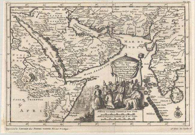
This striking small map depicts stretches from the Horn of Africa to India, centering on the Arabian Peninsula. It names several towns and cities, including Suez, Jerusalem, Damascus, Madinah, Mecca, Baghdad, Shiraz, and Surat. The origin of the Nile is depicted in Abissinia. Both Ankary and Tibbetts note that the shape of the Arabian Peninsula is poorly rendered. The map appeared in the Dutch translation of the travels of Nuno da Cunha that was published in Van der Aa's compendium De Aanmerkens-Waardige Voyagien door Francoisen, Italiaanen, Deenen, Hoogduytsen en Andere Vreemde Volkeren Gedaan na Oost- en West-Ind (1706). Cunha was the Governor of Portuguese India from 1529 to 1538. The title refers to "the Great Turk," Suleiman the Magnificent, the sultan of the Ottoman Empire from 1520 to 1566. During his reign there were several conflicts with the Portuguese around the Indian Ocean, including the Siege of Diu (1531), which pitted Ottoman-Gujarati forces against Cunha. The title cartouche depicts a scene of capture and torture against a backdrop of ships. The map was originally issued on a sheet with another map.
References: Ankary, pp. 266-67; Tibbetts #1707.
Condition: A
A sharp impression with a hint of printer's ink residue.