Subject: Baltic & Eastern Europe
Period: 1589 (circa)
Publication:
Color: Black & White
Size:
15.8 x 12.8 inches
40.1 x 32.5 cm
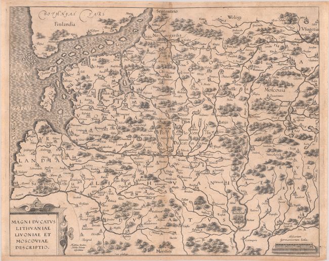
This rare map of the Duchy of Lithuania, Livonia, and Moscovia is the only surviving map of Maciej (Matthias) Strubicz (1530-1604). Strubicz was a Polish cartographer who worked as a geographer for Stephen Bathory, King of Poland and Grand Duke of Lithuania. In the late stages of the Livonian War (1558-83), Strubicz produced a map of the theater of war that assisted the Polish and Lithuanian forces against the army of Ivan the Terrible. This is the later, improved edition of that map, published in Cologne by Marcin Kromer. The map centers on Duna (Daugavpils) and covers from Curlandia (Courland) east to Moscow. It extends to show the southern coast of Finland in the north and part of present-day Belarus in the south. There is terrific topographical detail of watershed and forests. The map is decorated with a strapwork title cartouche, a distance scale, and a moiré-patterned sea. Strubicz is credited to the right of the title cartouche: "Matthias Strubicz Nobilis Polonus Describebat." A great find for collectors of the region - this is the first example of the map we have seen on the market since 2007.
Strubicz is best known for conducting surveys of the Polish-Lithuanian Commonwealth for Prince Michael Radziwill beginning in 1586. The resulting map was the most accurate rendering of Lithuania to that point in time and served as a resource for all other maps of the region for 150 years. Initially issued as a wall map in 1613 and then included in Blaeu’s atlases beginning in 1631, Magni Ducatus Lithuaniae was the first published map to include the name “Ukraina.”
References:
Condition: B
A crisp impression on watermarked paper with light toning and a few short wormtracks along the centerfold that have been infilled on verso with archival materials. There is some light soiling and hinge tape along the sheet's edges on verso.