Subject: Baltic Sea
Period: 1671 (circa)
Publication:
Color: Hand Color
Size:
22.3 x 19.3 inches
56.6 x 49 cm
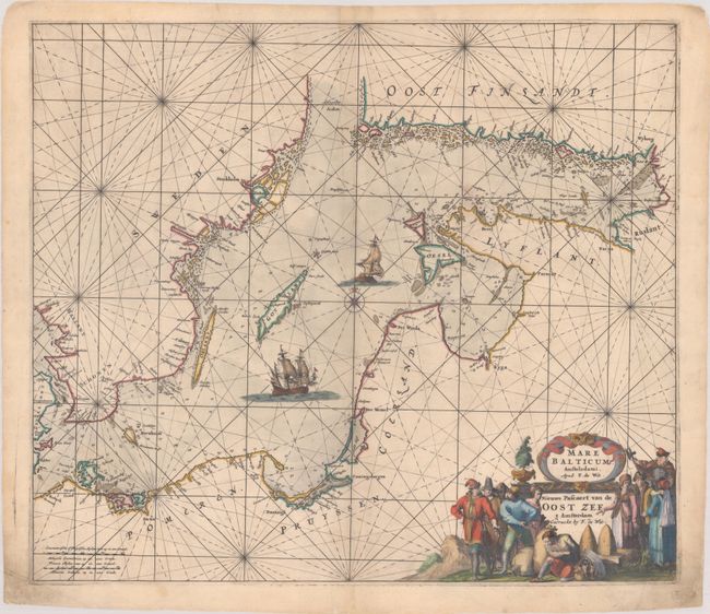
This elegantly engraved chart of the Baltic Sea features navigational information such as soundings, anchorages, and hazards. Aside from place names along the coast, there is no inland detail. Major cities are identified in big, bold letters, including Szczecin, Gdansk, Coningsbergen (Kaliningrad), Der Memel (Klaipeda), Riga, Parnu, Revel (Tallinn), Vyborg, Aboo (Turku), and Stockholm. Rugen, Bornholm, Oland, Gotland, Oesel (Saaremaa), Dageroort (Hiiumaa), and myriad smaller islands are located. The chart is crisscrossed by rhumblines and is further decorated by two massive sailing ships and a compass rose at center. At bottom right the Latin and Dutch titles are enclosed by an elaborate figurative title cartouche featuring merchants and noblemen and women in local dress. First state, with unnamed seas and no defined inland borders. The chart appeared in several De Wit atlases, including Orbis Maritimus ofte Zee Atlas, and was later issued by Renard and Ottens.
References: Carhart #C11.1; cf. Koeman, M.WIT 1 #7.
Condition: B+
A crisp impression with minor foxing and a printer's crease at top. In the bottom corners, there is some soiling and a couple edge tears and a marginal chip that have been repaired with archival materials.