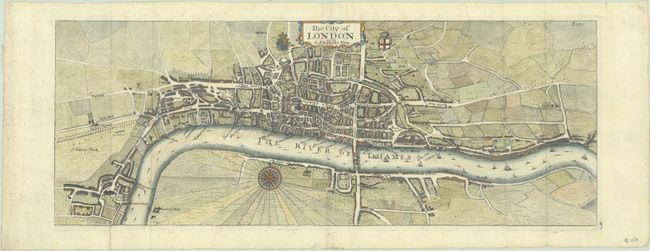
Subject: London, England
Period: 1720 (circa)
Publication: A Survey of the Cities of London and Westminster...
Color: Hand Color
Size:
18.2 x 6.9 inches
46.2 x 17.5 cm
This charming bird's-eye plan of London extends from Lambeth to Ratcliff. A number of streets, wharves, and other locations are labeled. Embellished with a compass rose, the Royal arms, and the arms of London. This map was published in John Strype's reissue of John Stow's Survey of London, which Strype updated and enlarged with maps of London and its parishes. Strype's work included two maps of London, the other being a larger map titled A New Plan of the City of London, Westminster, and Southwark, which is often attributed to Herman Moll. This smaller map bears no attribution, and is not listed in Darlington & Howgego's Printed Maps of London circa 1553-1850.
References: Shirley (BL Atlases) T.STRY-1a #2.
Condition: B+
A nice impression, issued folding on a bright sheet with faint foxing and an archivally repaired tear in the bottom left corner of the map.