Subject: Lima, Peru
Period: 1753-92 (circa)
Publication:
Color: Hand Color
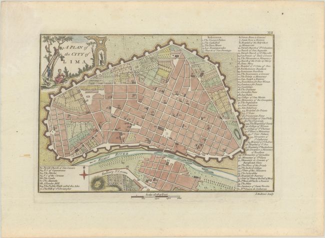
A. A Plan of the City of Lima, by John Andrews, from A Collection of Plans of the Most Capital Cities of Every Empire..., circa 1792 (9.6 x 6.4"). This handsome bird's-eye plan of Lima features nice detail of the fortified city. A key identifies 70 places of interest, including several colleges, a hospital, and locations of religious significance. The decorative title cartouche shows a pastoral scene with two men climbing trees. Reference: Phillips (A) #56-41. Condition: A nice impression on a sturdy sheet with a faint dampstain in the top left blank margin. (A)
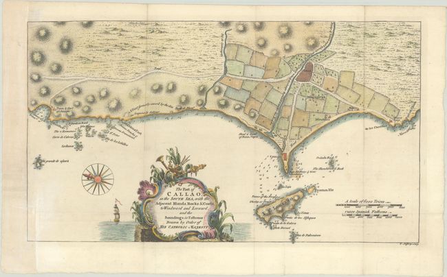
B. The Port of Callao, in the South Sea; with the Adjacent Islands, Rocks & Coasts, to Windward and Leeward, and the Soundings in Fathoms..., by Thomas Jefferys, from Gentleman's Magazine, published 1753, (14.3 x 8.2"). This interesting map covers the present-day Lima Metropolitan Area from the fishing village of Ancon to the fortifications of Callao and the city of Lima further inland. The map is very detailed with depth soundings, roads, and rivers. There is a decorative cartouche with a ship under full sail. A compass rose orients the chart with north on the left. Reference: Jolly #GENT-82. Condition: A crisp impression issued folding, now flat, on a sheet with a "B F" watermark. The margin has been extended as left with old paper, with the neatline at bottom left replaced in facsimile. Folds are reinforced with archival materials on verso. (B+)
References:
Condition:
See description above.