Subject: Lesser Antilles
Period: 1719 (published)
Publication: Atlas Historique, Tome VI
Color: Black & White
This interesting lot includes three maps with the original text section on the Lesser Antilles, with particular sections about St. Kitts, Guadeloupe and Martinique. The three maps are:
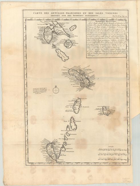
A. Carte des Antilles Francoises et des Isles Voisines Dressee sur des Memoires Manuscrits, (12.9 x 19.1"). This is Chatelain's version of Delisle's map of the Lesser Antilles that includes the interesting cartographic error of an upside-down Grenada. It extends from Guadeloupe to Grenada and includes Barbados. Numerous place names are shown, as are the locations of forts, churches, rivers, towns and villages. French text describes the European discovery and history of the islands.
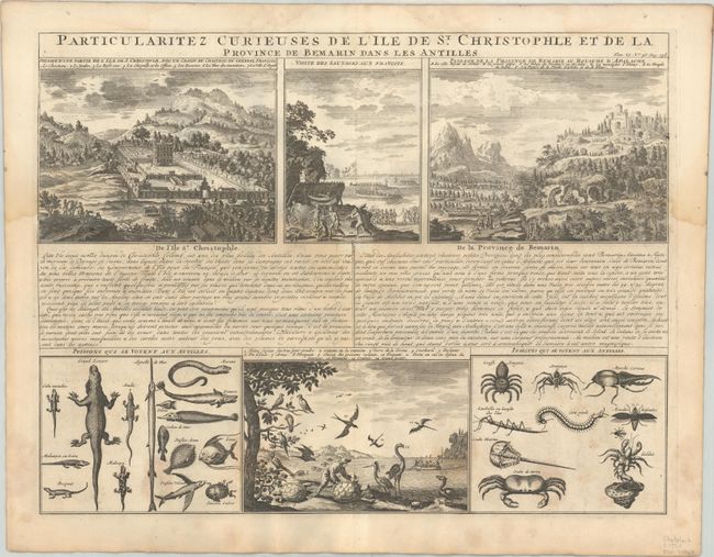
B. Particularitez Curieuses de l'Ile de St. Christophle et de la Province de Bemarin dans les Antilles, (19.3 x 14.8"). This sheet presents several views of St. Kitts and the native fauna. The view at upper left shows the Governor-General's palace - complete with elaborate formal French gardens. The view at center shows the natives welcoming the French and preparing a feast. The view at right depicts Melilot, the mythical capital of Apalache. This idealized view was taken from Charles de Rochefort's view first published in his Histoire naturelle et morale des iles Antilles de l'Amerique [1658]. The Apalache were purported to have a utopian kingdom in Georgia and Florida, and to have been the ancestors of the Carib peoples. As Melilot was not found in North America, here it has been transferred to St. Kitts. The views at bottom shows a variety of native fauna.
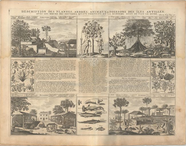
C. Description des Plantes, Abres, Animaux & Poissons des Iles Antilles, avec les Moeurs des Sauvages qui s'y Trouvent, et la Maniere dont on Fait le Sucre, (19.3 x 14.0"). This very boldly engraved sheet shows the commodities, natives and animals of the Antilles. The papayas, pineapples, peppers, bananas, peanuts and other useful plants are noted, and opossums, crocodiles, and wild boar are described as well. Other views show the houses of the workers and how they make sugar and indigo. Includes a panel of fish showing several sharks, dorado, bonito, and a manatee.
References: Koeman, Cha #16.
Condition: B
The maps are nice impressions, and the maps and text have damp stains in the lower 2/3 of the sheets. The first map is still attached to the text; the second and third maps are still attached to each other.