Subject: World, Aviation
Period: 1939 (circa)
Publication:
Color: Printed Color
Size:
37.6 x 23.1 inches
95.5 x 58.7 cm
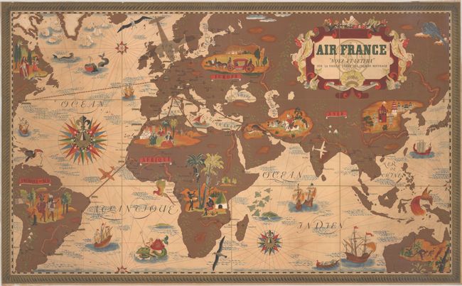
This vibrant map of the world was created by Lucien Boucher for Air France. It is roughly centered on Europe and the "Old World," extending to the Americas in the west and Australia in the south. The evolving routes of Air France are depicted with red overprinting, including destinations as far as Santiago, Chile and Hong Kong (with many stops in between!). The path from France to New York is still shown as a ship route as the first commercial flight between the two cities didn't occur until 1946. The continents are richly illustrated with welcoming natives, while the surrounding waters are filled with ships and several menacing sea monsters, including one ridden by Poseidon (suggesting it is safer to travel by air than sea). Further decorated by compass roses, rhumb lines, and a decorative rope border. Published by Perceval in Paris.
References: Rumsey #8543.
Condition: B
Bold color with light toning, scattered foxing, and light soiling. The map has been trimmed to the neatlines, with loss of the publisher's imprint and a portion of the neatline. There are some tiny tears and creases along the edges of the sheet.