Subject: Everett, Washington
Period: 1895 (circa)
Publication:
Color: Hand Color
Size:
27.6 x 40.4 inches
70.1 x 102.6 cm
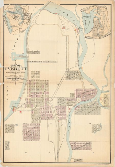
This rare plat map of Everett, Washington is based on original surveys compiled by Brown's Land & Engineering Co. It features remarkable detail of the city's expansion in its early days, with several additions located, including Bay View, Riverside, Mitchell Land and Improvement Co.'s, Land River Improvement Co., and Church andLa Moure's. Everett was conceived in 1890 as the "Pittsburgh of the West" by lumberman Henry Hewett, Jr. and railroad executive Charles L. Colby, who saw an opportunity to build an industrial center at the end of the Great Northern Railroad. The railroad is prominently depicted running down the center of the map, with the Seattle and Montana Railway shown along the Puget Sound. The course of Snohomish River snakes through the map as well. The Hotel Monte Cristo, factories, wharves, and steel, brick, and water works are identified. An inset at top left situates the city in the broader context of western Washington, while an inset at top right depicts the immediate vicinity. Published in Philadelphia by George William Baist. This is the only example of this map that we have found on the market.
References:
Condition: B
Issued folding with extraneous creasing and a few separations, the longest of which measures 5" at left. The top left corner is chipped with a small section of neatline missing, and there are two additional small chips along the border at left.