Subject: Washington
Period: 1865 (dated)
Publication:
Color: Hand Color
Size:
30.6 x 23 inches
77.7 x 58.4 cm
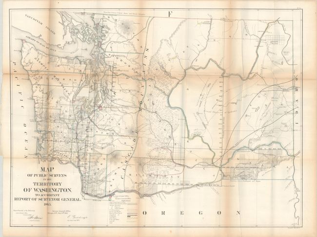
This hand-colored map of Washington Territory was issued in the GLO's annual report for 1866. It shows good detail in the coastal regions with additional completed surveying extending east along the Columbia River. Steven's proposed railroad route is shown and a legend at bottom identifies land offices, wagon roads, and minerals including silver, gold, lead and coal. Settlement is very sparse with only a few towns noted including Seattle, Vancouver, Walla Walla, and Olympia. Carl Wheat provides a detailed half-page description of the map. Of particular interest, he writes, “…we note such features of the map as ‘Lead & Silver Ledge’ on the eastern slopes of Mount Rainier, and ‘Gold Mines’ northeast of Lake Chelan, on the Similkameen, on the Columbia between Priest Rapids and White Bluffs, near the mouth of Spokane River, near the mouth of Clark Fork, and on the Snake opposite Lewiston.” This is one of the scarcer Washington Territory GLO maps and the first in the GLO maps series to employ color.
References: Phillips (Atlases) #1388-22; Wheat (TMW) #1130.
Condition: B
Issued folding with contemporary outline color and light toning along the fold lines. A number of short fold separations have been closed on verso with tape and there are minor losses at two fold junctions at left.