Subject: Republic of Texas
Period: 1838 (dated)
Publication: An Illustrated Atlas, Geographical, Statistical, and Historical, of the United States...
Color: Hand Color
Size:
11.2 x 14.4 inches
28.4 x 36.6 cm
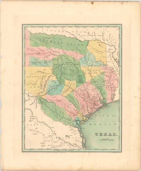
This early and large edition Independent Republic of Texas map was patterned on Stephen Austin's seminal map, albeit with better detail of the empresario grants, roads, and new settlements. The Texas General Land Office's Texas map reference refers to the second 1838 edition as "one of the best of the early Republic maps to appear in an atlas." The map presents the empresario grants, lakes, rivers, creeks, towns, and Indian villages. The Old Mexican Garrison is located on the Brazos River north of Deer Creek. Bradford considered the border with Mexico in the west and south to be undecided; here the southern border is at the Nueces River rather than the Rio Grande and the northern boundary is along the Red River. The map locates and names San Antonio de Bexar, San Felipe de Austin, Sabine, St. Augustine, Nacogdoches, Zavala, Tivis, Houston, Montezuma, Waco Village, Tenoxititlan, and more. There are approximately 17 grants named, including Stephen F. Austin, Woodbury & Cos, Cameron's, (two separate parts), Zavalla's and Whelin's. The large region around Austin is called Austin's Colony. Engraved by G.W. Boynton. Accompanied by three pages (on two sheets) of related text entitled "Republic of Texas."
References: Day #32; Phillips (M) p. 842; Phillips (Atlases) #1381; Ristow pp. 270-271; TX GLO pp. 132-35.
Condition: A
A crisp impression with full contemporary color. There is some minor foxing in the blank margins. One of the two pages of accompanying text is moderately tattered along the edges.