Subject: Maryland
Period: 1873 (published)
Publication: New Topographical Atlas of the State of Maryland
Color: Hand Color
Size:
24.4 x 14.8 inches
62 x 37.6 cm
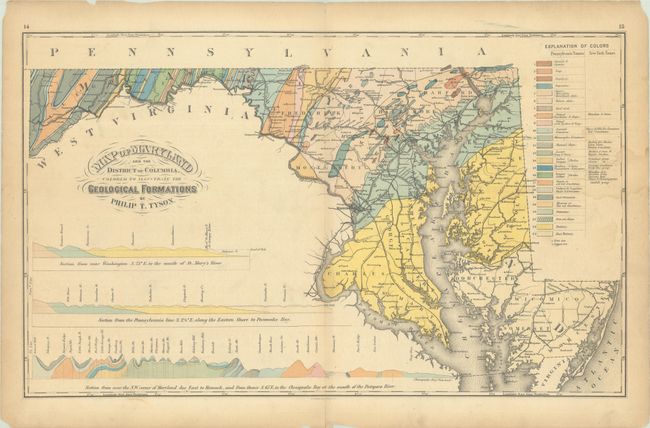
This geological map of the state was issued in Walling & Gray's New Topographical Atlas of the State of Maryland. It is based upon Tyson's 1859 map, which is the first geological map of Maryland. It covers the entire state and identifies 24 different geological types including granite, trap, coal and iron ore. Tyson based the rock classification scheme on H.D. Rogers' geological map of Pennsylvania with the New York survey names also shown. Beneath the map image are three profile views: Near Washington to the mouth of the St. Mary's River, Pennsylvania line along the Eastern Shore to Pocomoke Bay, and NW corner of Maryland due east to Hancock and the Chesapeake Bay.
References: cf. Marcou & Marcou #283.
Condition: B
Contemporary color with light toning, a faint dampstain along the right border, and a pair of 1.25" archivally repaired tears at top left and right. An edge tear at left that just enters the border and a short centerfold separation at bottom have both been repaired.