Subject: Southern Maine
Period: 1878 (dated)
Publication:
Color: Black & White
Size:
23.7 x 37.8 inches
60.2 x 96 cm
The Office of Coast Survey is the oldest U.S. scientific organization, dating from 1807 when Congress directed that a "survey of the coast" be carried out. By 1836, it was called the U.S. Coast Survey and in 1878, the name was changed to the U.S. Coast and Geodetic Survey. Today the Office of Coast Survey is a division of the National Oceanic and Atmospheric Administration NOAA.
The survey teams, composed of civilians as well as Army and Naval officers, charted the nation's waterways and produced a wide array of reports, survey charts, hydrographic studies of tides and currents, astronomical studies and observations, and coastal pilots. These charts are an important record of the changing nature of the nation's coastlines. In additional to coastal charts, the U.S. Coast and Geodetic Survey produced land sketches, Civil War battle maps, and the early aeronautical charts.
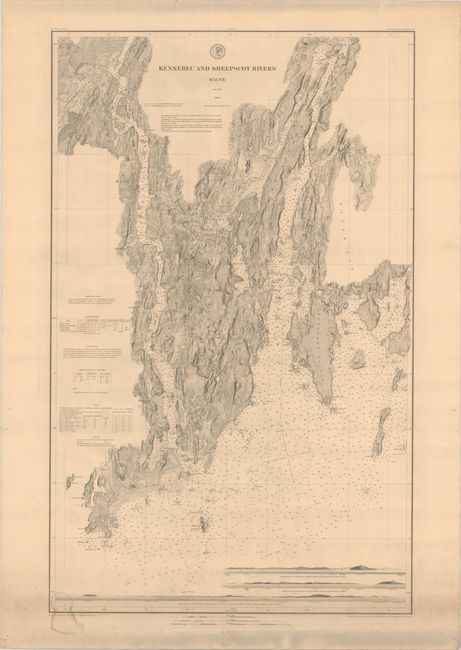
This separately issued chart is printed on heavy paper unlike the folding versions typically found in the Coast Survey annual reports. It provides superb detail of a small stretch of southern Maine (about 13 miles wide) from Bath northeast to Wiscasset and points south including Arrowsic, Georgetown, and Southport islands. Details on the water include scores of soundings, ground types, buoys, lighthouses. On land, topography, vegetation, roads, and even individual buildings are noted. Along the bottom of the map are three approach views to Kennebec while notations on lighthouses, tides, and buoys are located along the left border. First issued in 1868 and updated to 1878.
References:
Condition: B+
A strong impression on a sturdy sheet with a small dampstain and minor soiling at bottom. There are a few edge tears confined to the top blank margin.