Subject: Mammoth Cave, Kentucky
Period: 1882 (dated)
Publication:
Color: Black & White
Size:
10.3 x 8 inches
26.2 x 20.3 cm
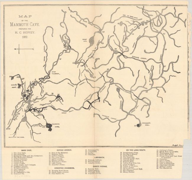
This small map depicts Mammoth Cave, the longest cave network in the world with over 400 miles explored. It accompanied a talk given by Horace C. Hovey to the American Geographical Society in 1891 describing his experience exploring this underworld. The map itself presents an elaborate and interwoven cave system with various avenues, domes, and 64 locations keyed to the map including the Iron Gate, Giant's Coffin, Seat of the Mummy, Fat Man's Misery, Black Hole of Calcutta, and many more. Hovey, a founding father of speleology, told the audience that "you are now invited to visit a region below the surface; a sunless realm that has, however, its mountains, plains and valleys, its lakes, rivers and cascades, its unique and extensive fauna and flora, and that claims a degree of attention not yet accorded to it by scientific men." Hovey published several other works related to Mammoth Cave including Celebrated American Caverns (1882) and 15 editions of The Mammoth Cave of Kentucky (first published in 1897). 34 pages, disbound.
References:
Condition: B+
The folding map was issued on "Commercial Bond 1890" paper with an archivally repaired 1.75" fold separation at top. Trimmed to the border at right by the binder with some minor loss of border at bottom. Disbound text is lightly toned.