Subject: Key West, Florida
Period: 1985 (dated)
Publication:
Color: Printed Color
Size:
33 x 23.7 inches
83.8 x 60.2 cm
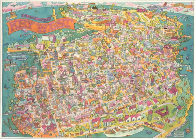
This colorful pictorial map promoting local Key West businesses was drawn by Ron Baeza in Key West and published by White Mountain Graphics in New Hampshire. It covers the entire entire island from Fort Zachary Taylor east to the airport and Stock Island. The majority of the map is focused on Old Town, locating Mallory Square, the Marina, the Southernmost Point in the continental U.S., Ernest Hemingway House, and numerous local establishments (who likely funded the map's production) including restaurants, hotels, and retail establishments. The map is decorated by numerous boats in the surrounding waters, airplanes, and a compass rose in the bottom right corner indicating north is to the top left. The banner-style title cartouche is shown as part of an aerial advertisement. We found only one institutional holding of this map (University of Florida).
References:
Condition: B
A colorful example with dampstaining along the left border and archivally repaired edge tears at top left (1.75") and lower right (1.5"). There are pinholes in the corners and several short edge tears at top that have also been archivally repaired. A few old pieces of tape on verso have been removed with some minor residue visible.