Subject: Montana & Wyoming
Period: 1937 (dated)
Publication:
Color: Black & White
Size:
14.9 x 9.6 inches
37.8 x 24.4 cm
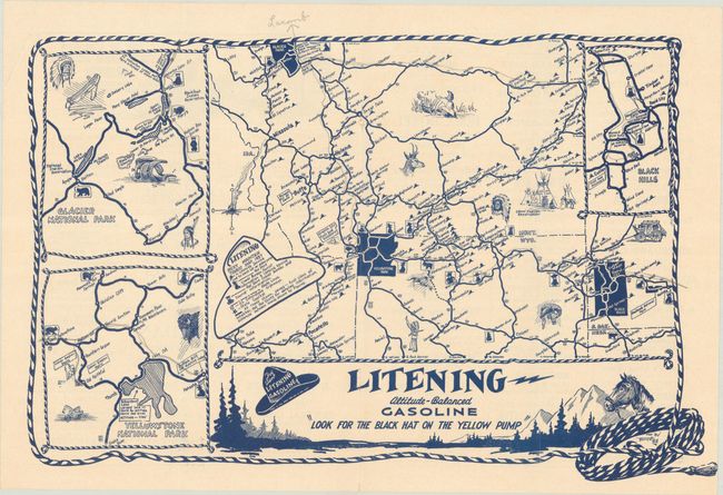
This road map in blue ink was drawn by Forrest Hill for Litening Altitude-Balanced Gasoline, a local refiner and distributer. The map covers parts of Montana, Wyoming, and western South Dakota with inset maps highlighting Yellowstone, Glacier National Park, and the Black Hills. A cowboy-shaped hat legend further identifies various Litening stations, highways, and first-class roads. The map is surrounded by a rope border to further reinforce the cowboy theme. The verso features local advertisements including a large illustrated advertisement for Sheridan Export Beer showing bears quaffing beer with a curious testimonial “Even the bears drink Sheridan Export Beer.”
Forrest Hill, a Montana native, painted the Depression-era mural “Montana Progress” for the Glasgow, Montana post office. It is one of the few New Deal murals remaining in Montana post offices.
References:
Condition: B+
There are staple holes along the centerfold, as issued, and some pencil notations in the image. Folded by a previous owner, with two extra vertical folds flanking the centerfold.