Subject: Central United States, Arkansas
Period: 1822 (published)
Publication: A Complete Historical, Chronological, and Geographical American Atlas...
Color: Hand Color
Size:
14.9 x 14.6 inches
37.8 x 37.1 cm
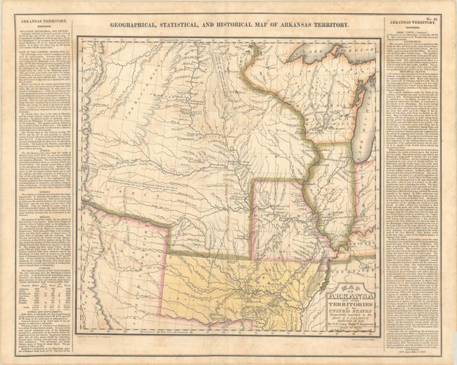
For this commercial atlas version of the seminal Stephen Long report map, Carey & Lea chose a single sheet format at a reduced scale with the political boundaries highlighted in color. It carries the cartouche title Map of Arkansa and Other Territories of the United States Respectfully Inscribed to the Hon. J.C. Calhoun Secretary of War by S.H. Long Major T. Engineers and appears on a full folio sheet with text measuring 22.2 x 17.8". This is one of the most important maps of the American West, which Wheat calls the "most interesting map in this Atlas." It covers the Missouri River Basin north to the Mandan villages and west to the Rocky Mountains. Long's map corrected a number of geographical inaccuracies, foremost the erroneous course of the Red River. As on Long's manuscript map the "Highest Peak," James Peak, and Spanish Peaks appear, and the routes of his expeditions are clearly delineated. Extraneous details, including Major Long's astronomical notations, camp site locations, and elevation profile were eliminated, and information about Arkansas and surrounding territories was added in columns framing the map at the sides. South of the Republican Fork appears the significant legend that reads "The Great Desert is frequented by roving bands of Indians who have no fixed place of residence but roam from place to place in quest of game"; this is a change from Long's report map, where he famously referred to the "Great American Desert." A note refers to "Pawnee villages deserted in 1810," whereas the Long map uses the date of 1820. Salt works, Potatoe Hills, a large number of Indian villages and lands, A Broad and extensive swell of Land called by the French Coteau de Prairie, and Say's route are among the interesting landmarks located. Thomas Say was the expedition's naturalist and entomologist, and is considered to be the father of American entomology. Engraved by Young & Delleker.
This is the first state of the Carey & Lea map. Claims are sometimes made that the first edition (1822) Carey & Lea map preceded the publication of the Long report map based on a date of 1823 for the report. However, both were actually published in 1822, making the distinction impossible to tell from date alone. Even Wheat erroneously assigns an 1823 date to the Long report map. An interesting question that deserves further study.
References:
Condition: B+
A crisp impression with full contemporary color on a sheet with light staining and foxing. A few edge tears at bottom have been archivally repaired on verso. Remnants of hinge tape on verso.