Subject: United States
Period: 1869 (published)
Publication:
Color: Hand Color
Size:
55.4 x 28.6 inches
140.7 x 72.6 cm
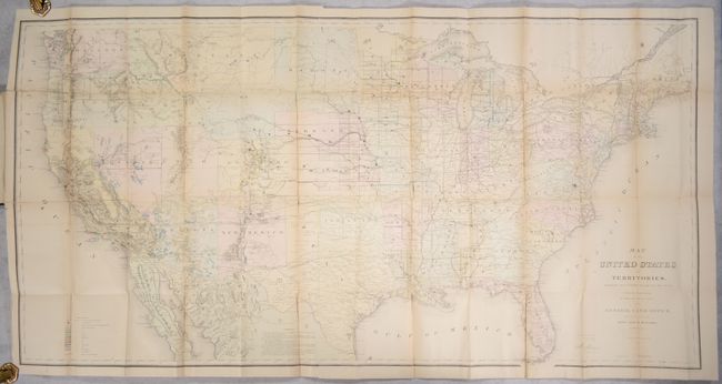
This is the scarce French language edition of Report of the Commissioner of General Land Office, for the Year 1867 issued to encourage immigration to the United States after the Civil War. While the text is French, the map retains its English format and is dated 1867. It is one of the more remarkable maps produced by the General Land Office. It shows the extent of the Public Surveys just after the Civil War and includes many features of great interest. Most significant are the gold, silver, copper, and other mineral deposits that are color-coded to mark their location. The sites of army forts and posts provide an excellent view of the undeveloped territories and the western frontier. Details include land grants, townships, subdivisions, railroads, mining districts, and more. Present-day Wyoming is unnamed and shown as part of the Dakota Territory. In the West, survey progress is still limited with much of Southern California complete, but only small areas of New Mexico and Arizona are complete, and with no surveys at all in Utah, Montana and Wyoming. The geological key also locates, via color and icon, deposits of quicksilver, iron, tin, asphalt, coal and oil springs that are shown scattered throughout the country. Constructed from Plats and Official Sources of the General Land Office under the direction of Hon. J.S. Wilson, Commissioner, by Joseph Gorlinski. Signed in the plate by Wilson. The General Land Office (GLO) was created in 1812 to oversee local land offices and in 1849 was incorporated into the Department of Interior.
The map is still bound into the back of the 201-page report. Octavo, hardbound in pebbled brown cloth with gilt title on front cover.
References: Wheat (TMW) #1168.
Condition: B
The large folding map, in full contemporary color, has a bit of foxing, minor toning along a few folds, and numerous fold separations throughout that have been closed on verso with archival tape. Text is mostly clean with occasional foxing and toning. Covers are very good with bumped corners.