Subject: United States
Period: 1821 (dated)
Publication:
Color: Hand Color
Size:
18.4 x 12 inches
46.7 x 30.5 cm
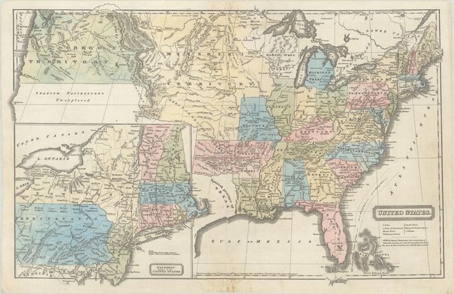
This early school atlas map by Woodbridge captures a very transitional United States as it expands towards the Pacific Ocean. In the Upper Midwest, Michigan is a territory, with its Upper Peninsula part of the neighboring Northwest Territory. The large Missouri Territory extends to the Canadian border and west to the boundary of Oregon Territory, which encompasses the present-day states of Oregon, Washington, and Idaho. Texas is named as a Spanish province, and a note north of the Red River reads, "The desert is traversed by herds of Buffaloes & wild Horses & inhabited only by roving tribes of Indians." The Great Basin and northern California are labeled "Spanish Possessions Unexplored" and left blank except for Cape Mendocino. A large inset at bottom left details the Northern Division of the United States, stretching from Chesapeake Bay to Lake Champlain. A key below the title identifies cities, small and large towns, seats of government, colleges, and missionary stations.
References:
Condition: B+
Full contemporary color on a bright sheet with light soiling that is mostly confined to the upper and lower margins. A 3" centerfold separation at bottom that has been repaired with archival materials on verso.