Subject: World
Period: 1684 (dated)
Publication: Cartes de Geographie les Plus Nouvelles et les Plus Fideles
Color: Hand Color
Size:
23.7 x 13.4 inches
60.2 x 34 cm
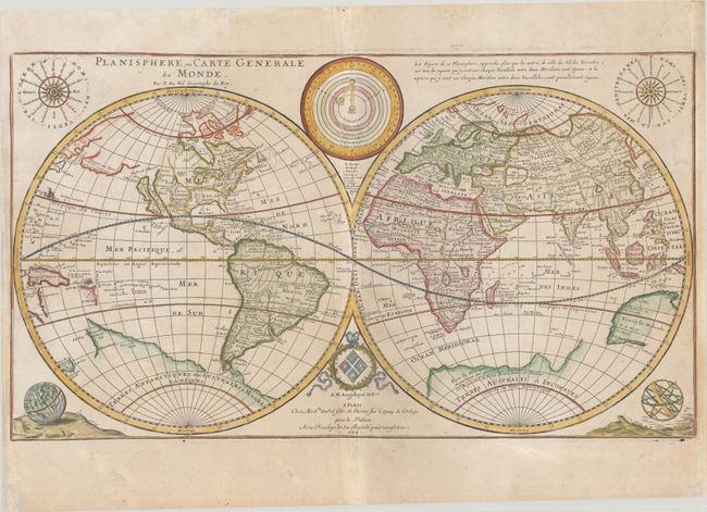
This is a later edition of Duval's double-hemisphere map, which was updated by his daughter after his death. First published by Pierre Duval in 1666, the map generally follows Sanson's world map of 1660 with the exception of the representation of Australia. Nouvelle Holande is depicted in an unusual and less accurate form, despite the fact that Duval's map of the East Indies gives an updated depiction of the continent. In North America, California is shown as an island, and a large Terre de Iesso spans nearly the entire North Pacific. Duval also depicts a massive southern continent (Terres Australes et Inconnues), which is connected to Nouvelle Zelande with Terre de Quir nearby. Surrounding the hemispheres are diagrams showing the planetary orbits and the ancient and modern names of the winds, as well as a terrestrial globe and an armillary sphere.
After Pierre Duval's death in 1683, one of his daughters (it is unknown whether Marie-Angelique or Michele succeeded him in the map trade) replaced his imprint at bottom and made numerous geographic changes to the plate. Rodney Shirley believed that the daughter re-engraved the plate, however close inspection of the earlier and later maps proves that this is the same plate. There are clear erasures of the original engraver's imprint (Louis Cordier) just below the eastern hemisphere on the daughter's map, and the plate mark matches in both examples. The daughter made a number of important updates to the map, all within the western hemisphere. Previously open-ended, the western coasts of Lake Superior and Lake Michigan were added, and the name of Lake Michigan was updated from Lac des Puans to Lac des Ilinois. In addition, the place names N. York and Fl. de S. Laurens were added, the shape of Hudson Bay was improved, and the mouth of the Rio Grande (R. de Nort) was moved from the Gulf of California to the Gulf of Mexico. In South America, the mythical L Parime was removed in Guyana and replaced with a mountain range. As the plate was fairly worn by 1684, some of the engraved lines were reinforced, however parts of the plate still show clear signs of wear.
This is one of the earliest world maps published by a woman, and is rarely found on the market.
References: Shirley #441 & #522; Pastoureau, DUVAL II E [11].
Condition: B+
A nice impression on a sheet with the watermarks of a large coat of arms and the initials "B[heart]C" for Benoit Colombier. There is light soiling, some minor creases that have been pressed flat, and an ink smudge along the Tropic of Cancer in the western hemisphere. The sides of the sheet have been professionally remargined, and there are additional professional repairs to a couple of separations along the centerfold at bottom and to a short tear in the solar system diagram at top center.