Subject: Colonial Northeastern United States & Canada, Great Lakes
Period: 1703 (dated)
Publication:
Color: Hand Color
Size:
25.6 x 19.7 inches
65 x 50 cm
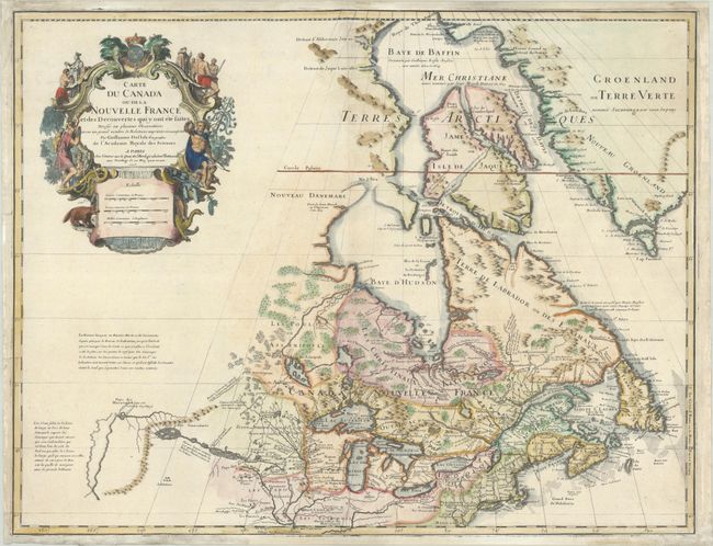
Delisle's map of Canada and the Great Lakes is one of the most outstanding and influential maps of the eighteenth century. The Great Lakes are portrayed correctly for the first time, and Detroit marks its debut on this map, only two years after its founding. Delisle's cartography is very meticulous and adds new information from Joliet, Franquelin, and the Jesuit explorers. It correctly positions the Ohio River but confuses its name with the Wabash River. West of the Mississippi Lahontan's fictitious Riviere Longue is prominently depicted. In Canada special attention is given to the rivers and lakes between Hudson Bay and the St. Lawrence, and Lac de Assenipoils (Lake Winnipeg) connects to Hudson Bay. Sanson's three islands of the Arctic are retained. Exquisite cartouche with a beaver, natives (one of whom is bearing a scalp), a priest, and friars, engraved by Guerard. This appears to be an unrecorded state between the first and second states, with Delisle's address reading "sur le Quai de l'Horlage a la Cour.ne de Diamans" but without Renard's imprint, published circa 1705.
References: cf. Kershaw #309; cf. Schwartz & Ehrenberg p. 135-137, Plt. 80; cf. Tooley (Amer), p. 20, #35a.
Condition: A
A crisp impression on a bright sheet with the watermarked of "A[heart]R" and a Maltese cross encircled in rosary beads. There is marginal soiling and a few minor printer's creases. The map has been professionally remargined at top and bottom, with a few tiny tears at the sides of the map also professionally repaired.