Subject: Northern Canada, Back River
Period: 1837 (circa)
Publication:
Color: Black & White
Size:
19 x 14.9 inches
48.3 x 37.8 cm
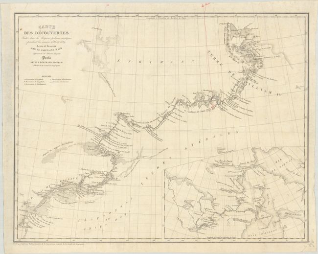
This scarce map charts the progress of the Back River Expedition of 1833-34. It is the French edition of Back's Map of the Discoveries and Route of the Arctic Land Expedition, in the Years 1833 & 1834 (1836). In February 1833, Captain George Back departed from England on a mission to locate explorer John Ross, missing since departing for an expedition to the Arctic in 1829. He arrived at Great Slave Lake in August and located the Grande Riviere du Poisson (Great Fish River, now known as Back River), where Ross was presumed to be. After wintering at Fort Reliance, Back received word that Ross had returned to England. His new mission was to explore the coast from King William Land to Point Turnagain. Over the summer of 1834 he traveled the river through arduous rapids to King William Island before returning to Fort Reliance. The map notes Back's journey, dating his progress up the river and noting points where he observed coordinates and magnetic variations. Artillery Lake, Clinton-Colden Lake, and other small lakes are noted along the river's course. Conjectural bodies of water are noted as "d'apres le rapport des Indiens" (according to Indians' report). A large inset at bottom right expands coverage to show the region from Mackenzie River to Baffin Bay. Engraved by Ambroise Tardieu for the Societe de Geographie, edited by Arthus Bertrand.
References:
Condition: B+
A crisp impression with light soiling, minor foxing, and a red ink manuscript notation at top right.