Subject: World
Period: 1651 (circa)
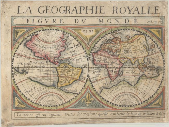
Publication: Carte Generalle de la Geographie Royalle
Color: Hand Color
Size:
7.8 x 5.3 inches
19.8 x 13.5 cm
This attractive double-hemisphere world map depicts the large mythical continent of Terra Australis across the southern portion of the map, incorporating New Guinea. The northwest coast of North America is greatly exaggerated with the Anian R depicted just below the Arctic Circle and California is shown in insular form. Virginia, Florida and Norombega are located along the east coast and the Great Lakes are entirely omitted. The fabled golden city of Manoa is located on the mythical and unnamed Lake Parime in South America. In Asia, the eastern coastline is truncated and Korea is noted as an island (though it appears to be peninsular). The map is decorated in the cusps by a fleur-de-lis and sun containing the word Jehovah in Hebrew. Prepared by Nicolas Berey and Hugues Picart. Although this map is typically attributed to Christophe Tassin, to whom the atlas (Carte Generalle de la Geographie Royalle) was attributed, the atlas wasn't published until 1651, several years after Tassin had ended his commercial activity and sold his plates to Nicolas Berey and Antoine de Fer. It is therefore more likely that the map was created by Berey, whose imprint is included on the map.
References: Pastoureau, TASSIN I A [1]; Shirley #391.
Condition: B
A crisp impression on a lightly toned sheet with some soiling and a bit of show-through of old manuscript notations on verso. There are professional repairs to chips and small holes along the edges of the sheet, with a small portion of the neatline replaced in facsimile at bottom.