Current Auction
Lot 620
Current Auction

"A New Mapp of Africa Designed by Mounsir Sanson, Geographr to the French King...", Blome, Richard
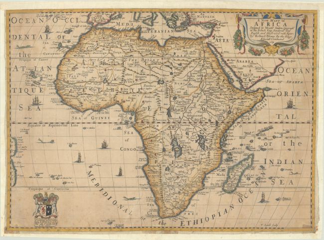
Subject: Africa

Period: 1669 (dated)

Publication: Geographical Description of the Four Parts Of The World

Color: Hand Color

Size:
20.7 x 15 inches
52.6 x 38.1 cm
Download High Resolution Image
(or just click on image to launch the Zoom viewer)

This beautiful map of Africa is based on Sanson's map of 1650, however with some new decorative elements, including ships, sea monsters, and an ostrich and a camel in the interior of Africa. Blome also added a heraldic dedication, which was updated over the lifespan of the map, and recognized the patron who was sponsoring the map. This example is the second state, with the dedication changed to John Edgerton, Earl of Bridgewarer. Cartographically, the map depicts Africa as it was understood prior to European exploration of the continent in the sixteenth century. Although the outline of the continent is more up-to-date, the geography of the interior is based on Ptolemy and other ancient sources. The map is filled with spurious details including the twin lake sources of the Nile and peculiar mountain ranges. It includes the Canary and Cape Verde Islands, as well as several other Atlantic islands and the coastline of Brazil. Madagascar and many islands in the Indian Ocean also appear. The map was engraved by Francis Lamb, who copied Sanson's strapwork and garland-style title cartouche. There is an excellent biography of Blome on MapForum.com.

See also lot 716 for Oscar Norwich's Norwich's Maps of Africa - An Illustrated and Annotated Carto-Bibliography that describes this map.

References: Betz #111; Norwich #42; Shirley (BL Atlases) T.BLOM-1a #9.

Condition: B

A sharp impression, issued folding on a toned sheet with a fleur-de-lis watermark and light foxing. There are old tape stains along the bottom edge of the map. The map has been professionally backed in thin, Japanese tissue, repairing a few tiny fold separations and tears, and has been professionally remargined on all sides to accommodate framing, as Blome's maps often had very narrow margins to fit within his atlas.

Estimate: $700 - $850

Sold for: $500

Closed on 6/18/2025

Closed