Subject: Western Mediterranean
Period: 1868 (dated)
Publication:
Color: Hand Color
Size:
35.6 x 24.3 inches
90.4 x 61.7 cm
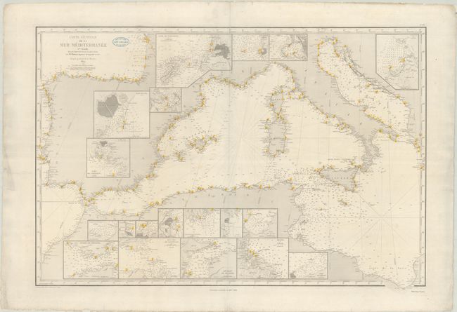
This remarkable chart, prepared by hydrographer Pierre Daussy, covers the western portion of the Mediterranean, from the Strait of Gibraltar to the Adriatic Sea and the Gulf of Sirte. The seas are full of bottom types, countless depth soundings, and other navigational information, with numerous lighthouses located with yellow and red dots. Place names line the coasts, but there is no inland detail. The chart incorporates 19 insets zooming in on various ports, bays, and passages, including Barcelona, Marseille, Civitavecchia, Trieste, Tangier, Algiers, Tunis, the straits of Gibraltar and Messina, Malta, and Tripoli. Originally printed in 1849, this example has been corrected to 1867-68. Engraved by Jacobs, with lettering by J.M. Hacq. Price is shown as "Deux Francs" under neatline at bottom right.
References:
Condition: B+
A nice impression on watermarked paper with a "Capne. Aristide Briand Nantes" stamp to the right of the title. The sheet has been professionally backed with archival tissue, closing marginal edge tears and two centerfold separations, including a 6.5" separation at top. There is light soiling and a couple minor abrasions along the top border.