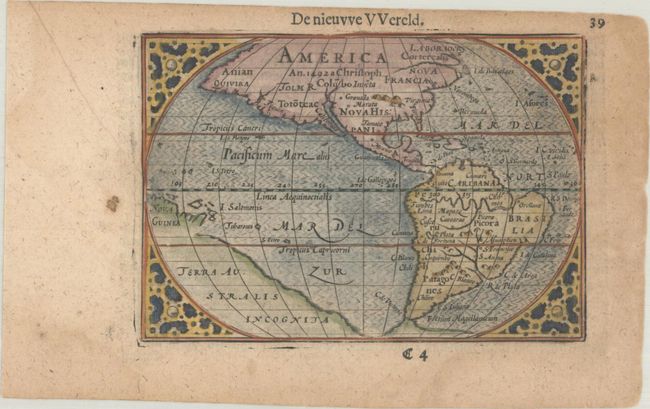
Subject: Western Hemisphere - America
Period: 1609 (published)
Publication: Hand-Boeck of Cort Begrijp der Caerten
Color: Hand Color
Size:
4.9 x 3.4 inches
12.4 x 8.6 cm
This charming miniature map was based on the 1587 folio map by Abraham Ortelius. A notation in North America notes its discovery by Christopher Columbus in 1492. Mythical locations such as Quivira, Norombega, Granada, and Marata are named in North America. The area north of Quivira is called Anian and a river extending from the west coast is labeled Tolm R. While the whole of the present-day United States is misshapen, the Mid-Atlantic region, labeled Virginia, is especially protuberant, with a spurious mountain chain to the west. A massive continent named Terra Australis Incognita and a fragment of Nova Guinea appear with incomplete coastlines. Dutch text on verso.
The map was first published by Cornelius Claesz and printed by Barent Langenes in the 1598 edition of the popular Map-treasury.
References: Burden #92; King (2nd ed.) pp. 80-82; Van der Krogt (Vol. III) #9000:341.
Condition: B+
A dark impression on a lightly toned sheet with a small paper flaw in the left margin and faint dampstains in the corners of the sheet.