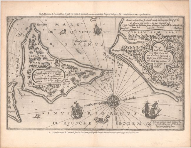
Subject: Saaremaa, Estonia
Period: 1600 (circa)
Publication: Le Nouveau Miroir des Voiages Marins de la Navigation de la Mer Occidentale & Orientale
Color: Black & White
Size:
20 x 12.9 inches
50.8 x 32.8 cm
This stunning and rare sea chart depicts the island of Oesel (Saaremaa) in the Gulf of Riga. The island is depicted with a generally correct shape with a few coastal cities and graphic depictions of forests and hills. Much of the interior is filled in by a strapwork distance scale cartouche. The chart extends across the De Strate van Ryghe (Irbe Strait) to show part of the Courland Peninsula in Latvia. The landscape there is similarly filled with pictorial depictions of topography, the decorative Dutch title cartouche, and coastal views. The waters are full of navigational information such as soundings, hazards, and anchorages along with decorative elements like sailing ships and massive fish. The map is from a French text edition of the Spieghel der Zeevaerdt, the first detailed atlas of charts covering the coastlines of Europe, originally published in Dutch in 1584-85. In addition to the Dutch and Latin titles on the map itself, an alternate French title appears along the upper neatline: Coste Maritime de l'Entiere Isle d'Oesel, & une Partie de Cuerlande, Commencante doiz Dageroor, Iusques a Der-vvinde... Waghenaer's charts are renowned for their fine engraving by the best craftsmen of the period, including Theodore de Bry and the Doetecum brothers. This map was engraved by Joannes Doetecum. French text on verso.
References: Koeman, Wag 11 A #38d.
Condition: B+
A dark impression with faint dampstaining that enters map image at right. Remnants of hinge tape on verso.