Subject: Baltic Sea
Period: 1658 (circa)
Publication:
Color: Hand Color
Size:
21.2 x 16.4 inches
53.8 x 41.7 cm
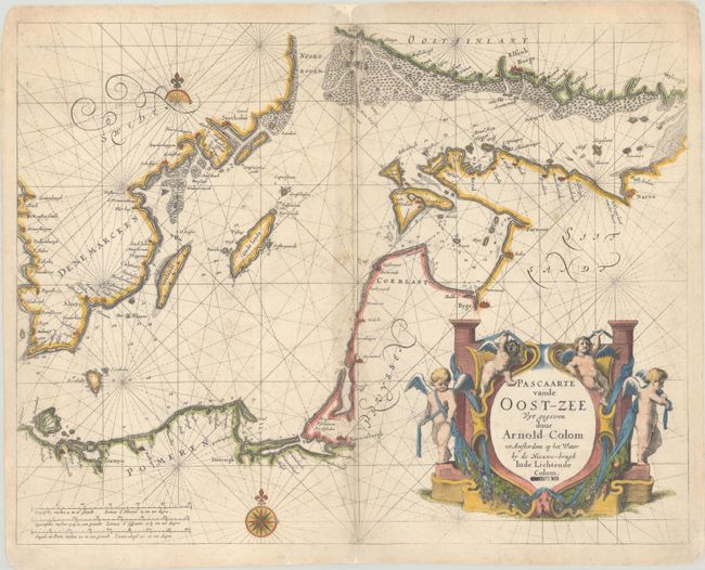
This rare and magnificent sea chart is credited to Arnold Colom, son of Jacob Arentsz Colom. It delineates the Baltic coastline from Rugen to the Gulf of Finland, with excellent detail of the Danish and Swedish coastlines as well. Several towns and cities of note are identified along the coast, including Szczecin, Gdansk, Konnixbergh (Kaliningrad), Riga, Parnu, Narva, Helsinki, Vyborg, Gothenburg, and Stockholm. Navigational information like soundings, anchorages, and hazards fill the sea. The map is further decorated by one-and-a-half compass roses and a large, ornate title cartouche at bottom right featuring garlands and putti draped in sashes. According to Tooley, this chart appeared in Colom's Zee-Atlas (1658), but Koeman's collation of that atlas shows Oost Zee door Arnold Colom, which covers the same stretch of coastline, but features many differences, chief among them a less ornate title cartouche and an inset of the Gulf of Finland. Nor is it to be confused with Jacob Aertsz Colom's Pascaert van de Oost-Zee Nieulix Wtgegeven (1663).
References: Tooley (MCC-70) #100.
Condition: B+
There is light foxing and minor soiling. Along the centerfold are short separations and a couple small chips that have been repaired with archival materials on verso. A "Colloredo" stamp appears in the title cartouche.